IMAGES TAKEN NEAR TO
High Street, BIRMINGHAM, B17 9PY
Introduction
This page details the photographs taken nearby to High Street, B17 9PY by members of the Geograph project.
The Geograph project started in 2005 with the aim of publishing, organising and preserving representative images for every square kilometre of Great Britain, Ireland and the Isle of Man.

There are currently over 7.5m images from over14,400 individuals and you can help contribute to the project by visiting https://www.geograph.org.uk
Image Map
Images are licensed for reuse under creativecommons.org/licenses/by-sa/2.0
Notes
- Clicking on the map will re-center to the selected point.
- The higher the marker number, the further away the image location is from the centre of the postcode.
Image Listing (23 Images Found)
Images are licensed for reuse under creativecommons.org/licenses/by-sa/2.0
Image
Details
Distance
1
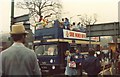
Open Top Bus, BRMB's first Walkathon
Pictured at a bus-stop in Harborne taking part in BRMB radio's very first 'walkathon', a charity event where people would walk the entire 'Outer Circle' bus route (anti-clockwise) - a distance of approximately 27 miles. The bus was used to ferry walkers who'd decided to stop at various checkpoints back to where they started. I remember this well - I did the whole route - got thoroughly drenched ! :)
Image: © Michael Westley
Taken: Unknown
0.05 miles
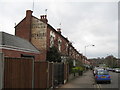
3
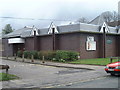
Harborne Baptist Church
On Harborne Park Road
Image: © Rebecca
Taken: 28 Mar 2001
0.08 miles
5
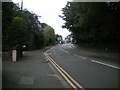
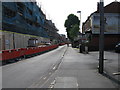
War Lane, Harborne (2)
Approaching the roundabout at the west end of High Street.
Image: © Richard Vince
Taken: 3 Sep 2022
0.10 miles
6

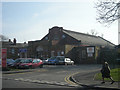
The (former) Royalty Bingo palace
Built in 1930 as a cinema for Selly Oak Pictures Ltd, and converted to use as a bingo hall in the '60s; it was still in operation until quite recently but suffered from a serious fire in the autumn of 2018 which seems to have brought an end (for the moment at least) to its operations. It was Grade II listed https://britishlistedbuildings.co.uk/101401284-the-royalty-gala-bingo-harborne-ward#.Xdqg-Oj7Tcs & https://historicengland.org.uk/listing/the-list/list-entry/1401284 in 2011. The second of the above 2 links gives an extensive description of the interior features, many of which are probably now lost to the aforementioned fire.
Image: © Richard Law
Taken: 2 Oct 2019
0.12 miles
7

The Vine and The Royalty
The Vine is a pub, The Royalty a Bingo venue.
Image: © Row17
Taken: 20 Mar 2009
0.13 miles
8
Harborne ghost sign - Birmingham
This ghost sign, advertising the services of builders A W Reynolds and Son, once was prominent on the gable end of a house in War Lane, Harborne, near the War Lane allotments but, sadly, since this photo was taken in 2011, the ghost sign has been painted over and is now no longer visible. There are many examples of these signs in Britain and the History of Advertising Trust and other websites on the subject hold an archive of examples from around the UK. Time taken 11.13 pm BST (British Summer Time).
Image: © Martin Richard Phelan
Taken: 1 Apr 2011
0.14 miles
9
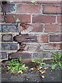
OS benchmark - Harborne, 2 Emerson Road
An OS cutmark on the external (garden) wall of no 2 Emerson Rd; originally levelled in 1962 at 171.228m above Ordnance Datum Newlyn.
Image: © Richard Law
Taken: 2 Oct 2019
0.14 miles