IMAGES TAKEN NEAR TO
Station Road, BIRMINGHAM, B17 9LX
Introduction
This page details the photographs taken nearby to Station Road, B17 9LX by members of the Geograph project.
The Geograph project started in 2005 with the aim of publishing, organising and preserving representative images for every square kilometre of Great Britain, Ireland and the Isle of Man.

There are currently over 7.5m images from over14,400 individuals and you can help contribute to the project by visiting https://www.geograph.org.uk
Image Map
Images are licensed for reuse under creativecommons.org/licenses/by-sa/2.0
Notes
- Clicking on the map will re-center to the selected point.
- The higher the marker number, the further away the image location is from the centre of the postcode.
Image Listing (56 Images Found)
Images are licensed for reuse under creativecommons.org/licenses/by-sa/2.0
Image
Details
Distance
1
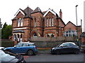
The Institute, Harborne
Originally built in the late 1870s as an Educational Institute, to a design by C Isaac Newey, albeit with alterations and additions in the intervening years. It stretches back some distance from the road, much currently in use as private offices. Extensive interior fittings and features remain. The whole building was Grade II listed https://britishlistedbuildings.co.uk/101380230-the-institute-harborne-ward#.XxBegShKjcs & https://historicengland.org.uk/listing/the-list/list-entry/1380230 in 2000.
Image: © Richard Law
Taken: 8 Jan 2020
0.01 miles
2
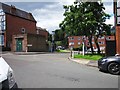
Frensham Way, Harborne
Frensham Way. The flats in the distance are built on the site of the former Harborne railway station.
Image: © Noisar
Taken: 21 Jun 2019
0.05 miles
3
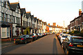
Station Road, Harborne
From near the junction with Frensham Way.
Image: © Phil Champion
Taken: 21 Jan 2006
0.05 miles
4
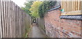
Path off Park Hill Road
This path leads from Park Hill Road to Station Road via Frensham Way. The path was created in the early 20th century to link Park Hill Road with the station approach in Station Road. It crossed the railway lines on a footbridge. The railway and bridge are no more. Frensham Way stands on their site.
Image: © Paul Collins
Taken: 23 Sep 2019
0.06 miles
5
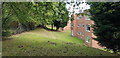
Back of Flats in Frensham Way
These flats were built on the site of Harborne station. The image was taken from a path created in the early 20th century to link Park Hill Road with the station approach in Station Road. It crossed the railway lines on a footbridge. The path remains, although the railway and bridge are no more.
Image: © Paul Collins
Taken: 23 Sep 2019
0.07 miles
6

Royal British Legion , Harborne
The British Legion is located in the Albany Social Club in Albany Rd just off the high St. There is a war memorial on the wall but there are no names on it.
Image: © Nigel Mykura
Taken: 3 Apr 2011
0.07 miles
7

Regent Rd, Harborne
Regent Rd runs parallel to the High St and just behind it. This is the view north from Albany Rd.
Image: © Nigel Mykura
Taken: 3 Apr 2011
0.07 miles

9

Harborne Library, Birmingham
The library occupies the premises of a 19th century Freemasons' Hall and an adjoining building on Harborne High Street.
Image: © A J Paxton
Taken: 13 Mar 2022
0.09 miles
10

Harborne Library, High Street
Partly in a (presumably former) masonic hall.
Image: © Richard Vince
Taken: 28 Jul 2018
0.09 miles