IMAGES TAKEN NEAR TO
Clarence Road, BIRMINGHAM, B17 9LA
Introduction
This page details the photographs taken nearby to Clarence Road, B17 9LA by members of the Geograph project.
The Geograph project started in 2005 with the aim of publishing, organising and preserving representative images for every square kilometre of Great Britain, Ireland and the Isle of Man.

There are currently over 7.5m images from over14,400 individuals and you can help contribute to the project by visiting https://www.geograph.org.uk
Image Map
Images are licensed for reuse under creativecommons.org/licenses/by-sa/2.0
Notes
- Clicking on the map will re-center to the selected point.
- The higher the marker number, the further away the image location is from the centre of the postcode.
Image Listing (69 Images Found)
Images are licensed for reuse under creativecommons.org/licenses/by-sa/2.0
Image
Details
Distance
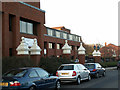
1
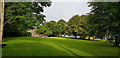
Open Space, Harborne
This pleasant little open space is edged on three sides by North Road and Nursery Road. Old maps show that at least until the 1950s, perhaps later, it was not open space, but contained buildings and their yards/gardens.
Image: © Paul Collins
Taken: 22 Aug 2019
0.08 miles
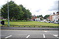
4
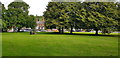
Open Space, Harborne
This pleasant open space is surrounded on three sides by North Road and Nursery Road. This was not always open space - until the 1950s, perhaps later, there were buildings and their curtilages here. The 'tree seat' appears never to have contained a tree, at least not for many years.
Image: © Paul Collins
Taken: 22 Aug 2019
0.08 miles
5
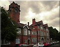
Harborne Police Station
Rose Road, Harborne.
Image: © Phil Champion
Taken: 21 Jan 2006
0.10 miles
6
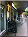
Valentino's Restaurant
A popular Italian restaurant on Harborne High Street, Birmingham. http://valentinosrestaurant.net/
Image: © Phil Champion
Taken: 15 Jun 2013
0.10 miles
7
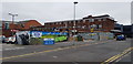
Rear of Shops, Harborne High Street
The mural at the extreme left is the site of a weekly sale of Grimsby fish. The building on the extreme right, on the south side of the high street, in a replacement building, erected about 2015.
Image: © Paul Collins
Taken: 23 Aug 2019
0.10 miles
8
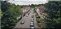
Park Hill Road viewed from Former Railway Bridge
The former railway bridge is now the Harborne Walkway footpath.
Image: © Paul Collins
Taken: 15 Aug 2021
0.10 miles
9
The Old Fire Station, Harborne
The former Fire station, Harborne, now Hockley Spiritualist Church
Image: © Noisar
Taken: 21 Jun 2019
0.10 miles
10
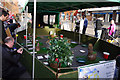
Owls on Harborne High Street
Central England Reptile Rescue and Bird of Prey Sanctuary were raising money and showing off some of their resident birds. http://cerr.co.uk/
Image: © Phil Champion
Taken: 8 Mar 2014
0.10 miles