IMAGES TAKEN NEAR TO
Cockthorpe Close, BIRMINGHAM, B17 8SD
Introduction
This page details the photographs taken nearby to Cockthorpe Close, B17 8SD by members of the Geograph project.
The Geograph project started in 2005 with the aim of publishing, organising and preserving representative images for every square kilometre of Great Britain, Ireland and the Isle of Man.

There are currently over 7.5m images from over14,400 individuals and you can help contribute to the project by visiting https://www.geograph.org.uk
Image Map
Images are licensed for reuse under creativecommons.org/licenses/by-sa/2.0
Notes
- Clicking on the map will re-center to the selected point.
- The higher the marker number, the further away the image location is from the centre of the postcode.
Image Listing (8 Images Found)
Images are licensed for reuse under creativecommons.org/licenses/by-sa/2.0
Image
Details
Distance
1
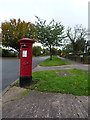
Fitzroy Avenue, Beech Lanes
Quiet suburban residential housing to the west of Birmingham city centre, here with Georgian postbox B17 585 at the side of the road.
Image: © Richard Law
Taken: 2 Oct 2019
0.07 miles
2
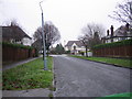
Beech Lanes
The name of this estate reflects the leafy nature of the area. This road leads to the loop of a road called Fitzroy Avenue.
Image: © Angella Streluk
Taken: 30 Dec 2005
0.12 miles
3

Open Space off Sir Richards Drive in Beech Lanes
This oblong open space was created when the estate was built and is attractively presented with lots of trees. Pictured here from Leigham Drive.
Image: © Paul Collins
Taken: 23 May 2017
0.14 miles
4

'Court Oak' pub sign & car park with church over the road
Image: © Row17
Taken: 29 Aug 2010
0.21 miles
5
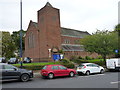
The Anglican church of St Faith and St Laurence, Harborne
Built in two phases, firstly in the late 1930s and then again in the late 1950s, to a design by the regional architect Philip Boughton Chatwin. Described in its 2009 Grade II listing https://britishlistedbuildings.co.uk/101393384-anglican-church-of-st-faith-and-st-laurence-quinton-ward#.XduD6eieRPY & https://historicengland.org.uk/listing/the-list/list-entry/1393384 as "The church is an elegant design of 1936-7 ... largely intact and unaltered ... the interior is broad and high with a sense of loftiness ... extensive stained glass as well as other high-quality furnishings."
Image: © Richard Law
Taken: 2 Oct 2019
0.21 miles
6
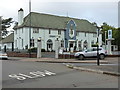
The Court Oak public house, Harborne
The Court Oak pub sits, effectively, in a roundabout surrounded by Court Oak Road on all sides.
Image: © Richard Law
Taken: 2 Oct 2019
0.23 miles
7
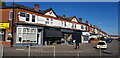
Businesses on Hampton Court Road
Like many shopping parades, this one nowadays offers mostly services. Besides the butchers there are two hair salons, a beauty salon and an empty unit. On the extreme left is a plumbing company. A Voi e-scooter for public rent awaits its next user.
Image: © Paul Collins
Taken: 8 Oct 2022
0.24 miles
