IMAGES TAKEN NEAR TO
Kelmscott Road, BIRMINGHAM, B17 8QW
Introduction
This page details the photographs taken nearby to Kelmscott Road, B17 8QW by members of the Geograph project.
The Geograph project started in 2005 with the aim of publishing, organising and preserving representative images for every square kilometre of Great Britain, Ireland and the Isle of Man.

There are currently over 7.5m images from over14,400 individuals and you can help contribute to the project by visiting https://www.geograph.org.uk
Image Map
Images are licensed for reuse under creativecommons.org/licenses/by-sa/2.0
Notes
- Clicking on the map will re-center to the selected point.
- The higher the marker number, the further away the image location is from the centre of the postcode.
Image Listing (5 Images Found)
Images are licensed for reuse under creativecommons.org/licenses/by-sa/2.0
Image
Details
Distance
1

Lordswood Road, Harborne (2)
Looking towards Harborne centre at the junction of Blakeney Avenue.
Image: © Richard Vince
Taken: 3 Sep 2022
0.13 miles
2
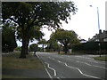
Lordswood Road, Harborne (1)
Looking towards Bearwood near the junction with Knightlow Road (right).
Image: © Richard Vince
Taken: 3 Sep 2022
0.16 miles
3

West end of Knightlow Road, Harborne
Off Lordswood Road.
Image: © Richard Vince
Taken: 3 Sep 2022
0.16 miles
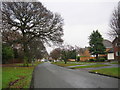
4

View along Gillhurst Road
1930s housing in the suburbs of Harborne, Birmingham.
Image: © Richard Law
Taken: 2 Oct 2019
0.19 miles
5
Blakeney Avenue
Due to the busy nature of the Hagley Road certain routes are used to get from Fitzroy Avenue to the Hageley Road. This road is a good way to get to traffic lights which allow one to turn right or left onto the Hagley Road.
Image: © Angella Streluk
Taken: 30 Dec 2005
0.20 miles