IMAGES TAKEN NEAR TO
Cross Farm Road, BIRMINGHAM, B17 0ND
Introduction
This page details the photographs taken nearby to Cross Farm Road, B17 0ND by members of the Geograph project.
The Geograph project started in 2005 with the aim of publishing, organising and preserving representative images for every square kilometre of Great Britain, Ireland and the Isle of Man.

There are currently over 7.5m images from over14,400 individuals and you can help contribute to the project by visiting https://www.geograph.org.uk
Image Map
Images are licensed for reuse under creativecommons.org/licenses/by-sa/2.0
Notes
- Clicking on the map will re-center to the selected point.
- The higher the marker number, the further away the image location is from the centre of the postcode.
Image Listing (38 Images Found)
Images are licensed for reuse under creativecommons.org/licenses/by-sa/2.0
Image
Details
Distance
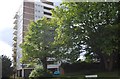
1
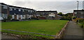
Bantock Way
This housing estate contains four tower blocks. Kendal Tower is larger than the other three. They are set in attractive parkland and the estate also has a lot of small blocks of terraced houses, as well as a lake. Bantock Way is a main pathway on the estate.
Image: © Paul Collins
Taken: 19 Oct 2022
0.06 miles
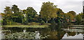
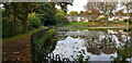
4
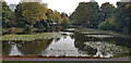
Lake off Cross Farm Road
This man-made lake was once in open fields but now forms an attractive feature in a housing estate. It is used for fishing.
Image: © Paul Collins
Taken: 19 Oct 2022
0.06 miles
5
Lake off Cross Farm Road
This man-made lake was once in open fields but now forms an attractive feature in a housing estate. It is used for fishing.
Image: © Paul Collins
Taken: 19 Oct 2022
0.06 miles
6
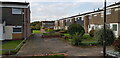
Bantock Way
This housing estate contains four tower blocks. Kendal Tower is larger than the other three. They are set in attractive parkland and the estate also has a lot of small blocks of terraced houses, as well as a lake. Bantock Way is a main pathway on the estate.
Image: © Paul Collins
Taken: 19 Oct 2022
0.07 miles
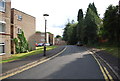
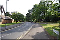
7
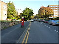
Metchley lane passing the western side of the Queen Elizabeth Hospital site
The QE Hospital is now the Birmingham University Medical School
Image: © Richard Law
Taken: 17 Oct 2019
0.08 miles
8
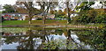
Lake off Cross Farm Road
This man-made lake was once in open fields but now forms an attractive feature in a housing estate. It is used for fishing. Leahurst Crescent is seen on the far side.
Image: © Paul Collins
Taken: 19 Oct 2022
0.09 miles
10
Lake off Cross Farm Road
This man-made lake was once in open fields but now forms an attractive feature in a housing estate. It is used for fishing. Leahurst Crescent is seen on the far side.
Image: © Paul Collins
Taken: 19 Oct 2022
0.10 miles