IMAGES TAKEN NEAR TO
Templefield Square, BIRMINGHAM, B15 2LJ
Introduction
This page details the photographs taken nearby to Templefield Square, B15 2LJ by members of the Geograph project.
The Geograph project started in 2005 with the aim of publishing, organising and preserving representative images for every square kilometre of Great Britain, Ireland and the Isle of Man.

There are currently over 7.5m images from over14,400 individuals and you can help contribute to the project by visiting https://www.geograph.org.uk
Image Map
Images are licensed for reuse under creativecommons.org/licenses/by-sa/2.0
Notes
- Clicking on the map will re-center to the selected point.
- The higher the marker number, the further away the image location is from the centre of the postcode.
Image Listing (51 Images Found)
Images are licensed for reuse under creativecommons.org/licenses/by-sa/2.0
Image
Details
Distance
1
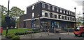
Templefield Square
Templefield Square consists of a Co-op convenience store plus five shop units, one apparently vacant at present. There are flats over the shops.
Image: © Paul Collins
Taken: 10 May 2023
0.01 miles
2
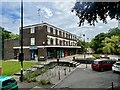
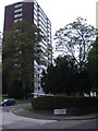
Templefield Square, Edgbaston
Constructed in the mid 1960s.
Image: © Andrew Abbott
Taken: 14 Jul 2024
0.02 miles
3
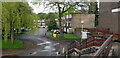
Melton Drive viewed from Templefield Square
Templefield Square consists of a small group of shops (with flats over) serving the local community.
Image: © Paul Collins
Taken: 10 May 2023
0.03 miles
4
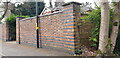
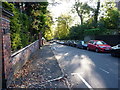
Old Brick Wall in Wheeleys Road with Benchmark
This old wall was presumably built when the houses fronting Carpenter Road were constructed. It has an interesting mixture of brick bonds and different coloured bricks. Near the base of the pillar is an Ordnance Survey cut benchmark. This benchmark is shown on the 1890 1/2500 map, but for some reason not on the 1904, 1919 or 1945 editions.
Image: © Paul Collins
Taken: 22 Mar 2024
0.05 miles
6
Looking east along Carpenter Road, Edgbaston
Image: © Richard Law
Taken: 17 Oct 2019
0.06 miles
8
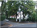
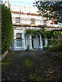
15 Carpenter Road, Edgbaston
Built around the mid 1830s as a 'detached stucco faced villa' and Grade II listed https://britishlistedbuildings.co.uk/101075670-15-carpenter-road-b15-edgbaston-ward#.XfP9hej7Tcs & https://historicengland.org.uk/listing/the-list/list-entry/1075670 in 1982.
Image: © Richard Law
Taken: 17 Oct 2019
0.08 miles
9
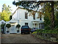
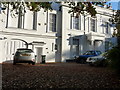
14 Carpenter Road, Edgbaston
Identical in design to the adjacent Image and of the same, mid 1830s construction. This too was Grade II listed https://britishlistedbuildings.co.uk/101343392-14-carpenter-road-b15-edgbaston-ward#.XeKO-Oj7Tcs & https://historicengland.org.uk/listing/the-list/list-entry/1343392 in 1970.
Image: © Richard Law
Taken: 17 Oct 2019
0.10 miles
10
13 Carpenter Road, Edgbaston
Much like the adjoining Image, No 13 was built around 1835, and is described in its Grade II listing https://britishlistedbuildings.co.uk/101075668-13-carpenter-road-b15-edgbaston-ward#.XeKM8Oj7Tcs & https://historicengland.org.uk/listing/the-list/list-entry/1075668 as "a detached 2 storey stucco villa of some pretention with coach home wing". The screen wall to the coach house (probably now a garage) on the left is original.
Image: © Richard Law
Taken: 17 Oct 2019
0.11 miles