IMAGES TAKEN NEAR TO
Summer Road, BIRMINGHAM, B15 2BP
Introduction
This page details the photographs taken nearby to Summer Road, B15 2BP by members of the Geograph project.
The Geograph project started in 2005 with the aim of publishing, organising and preserving representative images for every square kilometre of Great Britain, Ireland and the Isle of Man.

There are currently over 7.5m images from over14,400 individuals and you can help contribute to the project by visiting https://www.geograph.org.uk
Image Map
Images are licensed for reuse under creativecommons.org/licenses/by-sa/2.0
Notes
- Clicking on the map will re-center to the selected point.
- The higher the marker number, the further away the image location is from the centre of the postcode.
Image Listing (16 Images Found)
Images are licensed for reuse under creativecommons.org/licenses/by-sa/2.0
Image
Details
Distance
1
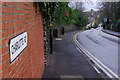
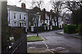
Charlotte Road, Edgbaston
Looking down the hill from the junction with Elvetham Road.
Image: © Stephen McKay
Taken: 9 Jan 2016
0.10 miles
2
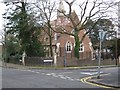
St James Church converted to flats
Corner of Charlotte Road and Elvetham Road, Edgbaston.
Image: © Roy Hughes
Taken: 10 Apr 2009
0.10 miles
3
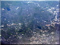
Southwest Birmingham from the air
With Edgbaston reservoir near the centre and Bartley and Frankley Reservoirs at upper right Image
Image: © M J Richardson
Taken: 4 May 2016
0.11 miles
4
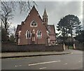
Former Church of St James, Edgbaston
Converted former church.
Image: © AJD
Taken: 1 Jan 2024
0.11 miles
5
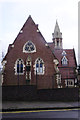
Former St James' Church, Edgbaston
Built in the 1840s, this building functioned as a church for over a century before becoming derelict. It was badly damaged by a fire in the 1970s apparently started by a tramp trying to keep himself warm. It has now been completely renovated and turned into apartments.
Image: © Stephen McKay
Taken: 9 Jan 2016
0.11 miles
6
Deeley Close From Parkfield Close, Edgbaston
Note to all Geographers -Does anyone know why the road is named "Deeley Close" please ?
Image: © Roy Hughes
Taken: 10 Apr 2009
0.15 miles
7
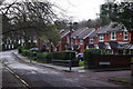
Elvetham Road, Edgbaston
Modern houses on the Calthorpe Estate.
Image: © Stephen McKay
Taken: 9 Jan 2016
0.15 miles
8
Elvetham road, Edgbaston
The bottom end of Elvetham Road where it joins Pakenham Road.
Image: © Stephen McKay
Taken: 9 Jan 2016
0.16 miles
9
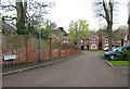
St James' Road, Edgbaston
To the right is West House School, an independent school for boys aged 4-11. It has occupied this site since it was founded in 1895.
Image: © Stephen McKay
Taken: 9 Jan 2016
0.18 miles
10

Park Central and James Brindley School
Taken from a 3rd floor balcony, this is a view of the area now called Park Central/Attwood Green and which was largely redeveloped in the mid 20th century and then again, to a much higher standard, in the early 21st. James Brindley School occupies the large group of buildings on the left. The old houses of Lee Crescent, many listed, can be seen in the distance just to the left of the large apartment block.
Image: © Paul Collins
Taken: 26 Jan 2022
0.19 miles