1
Wasteground, top of Sladepool Farm Road
Opposite shops, alongside Alcester Road South, there remains a strip of undeveloped land, on which people can walk. This view of land and estate beyond.
Image: © Michael Westley
Taken: 23 Apr 2010
0.04 miles
2
Alcester Road at Hawkhurst Road
The dual carriageway section of the A435 ends here. The remainder of the route is unimproved urban highway as far as Birmingham's A4540 ring road.
Image: © Peter Whatley
Taken: 7 Dec 2011
0.05 miles
3
Methodist Church car park
On far side of car park, nearest to fence, once stood air-raid shelters. Beyond are flats on Amwell Grove
Image: © Michael Westley
Taken: 23 Apr 2010
0.06 miles
4
Druids Heath Estate, Maypole
View from top of Sladepool Farm Road, looking across Alcester Road South to the estate, built in the late 60s. The approach to Methodist Church is on left of photo.
The grassy area ahead was once wasteground, unlevelled ground across which I spent many a happy time, playing and climbing trees.
Image: © Michael Westley
Taken: 23 Apr 2010
0.08 miles
5
Druids Meadow Care Home, Maypole
Situated on Manningford Road, Maypole
Image: © Michael Westley
Taken: 27 May 2010
0.09 miles
6
25 Sladepool Farm Road, Maypole (Our House)
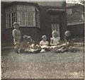
Not very recognisable from what it was 40 years ago - but this is my first family home - lived in til aged 11. Notice extension on side of house (no more sleeping 2 to a bedroom) and front garden turned into car parking. There was a large tree in front garden too - now that's gone.
See
Image] for 1959 style / view.
Image: © Michael Westley
Taken: 23 Apr 2010
0.09 miles
7
25 Sladepool Farm Road - 1959 style
Front garden with friends - semi-detached home on corner of Kemsley Road.
See
Image] for up-to-date view of house.
Image: © Michael Westley
Taken: Unknown
0.09 miles
8
Corner of Kemsley Road, Maypole
Junction with Sladepool Farm Road
Image: © Michael Westley
Taken: 23 Apr 2010
0.10 miles
9
Corner of Kemsley Road, Maypole
Semi-detached homes on corner of Sladepool Farm Road and Kemsley Road
Image: © Michael Westley
Taken: 23 Apr 2010
0.10 miles
10
Hoods, Carpet Store 40 + years
Hoods carpet store, on Alcester Road South, opposite Sladepool Farm Road, has been trading for more than 40 years, under ownership of the same family 'Hoods' - congratulations.
An old-fashioned hearse passes by in direction of Brandwood Cemetery.
Image: © Michael Westley
Taken: 23 Apr 2010
0.10 miles


