1
25 Sladepool Farm Road, Maypole (Our House)
Not very recognisable from what it was 40 years ago - but this is my first family home - lived in til aged 11. Notice extension on side of house (no more sleeping 2 to a bedroom) and front garden turned into car parking. There was a large tree in front garden too - now that's gone.
See
Image] for 1959 style / view.
Image: © Michael Westley
Taken: 23 Apr 2010
0.06 miles
2
Corner of Kemsley Road, Maypole
Junction with Sladepool Farm Road
Image: © Michael Westley
Taken: 23 Apr 2010
0.06 miles
3
Sladepool Farm Road
View from outside health centre, looking south-east
Image: © Michael Westley
Taken: 23 Apr 2010
0.07 miles
4
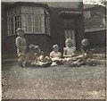
25 Sladepool Farm Road - 1959 style
Front garden with friends - semi-detached home on corner of Kemsley Road.
See
Image] for up-to-date view of house.
Image: © Michael Westley
Taken: Unknown
0.07 miles
5
Corner of Kemsley Road, Maypole
Semi-detached homes on corner of Sladepool Farm Road and Kemsley Road
Image: © Michael Westley
Taken: 23 Apr 2010
0.07 miles
6
Methodist Church car park
On far side of car park, nearest to fence, once stood air-raid shelters. Beyond are flats on Amwell Grove
Image: © Michael Westley
Taken: 23 Apr 2010
0.08 miles
7
Overgrown, Henlow Road, Maypole
Overgrown semi-detached, on corner of Henlow Road and Sladepool Farm Road
Image: © Michael Westley
Taken: 23 Apr 2010
0.08 miles
8
Gully on Sladepool Farm Road
Gully towards Littlecoat Croft - with ugly anti-motorcycle bars
Image: © Michael Westley
Taken: 23 Apr 2010
0.09 miles
9
Sladepool Farm Road, Maypole
View up towards Druids Heath Estate (blocks of flats in background) from gulley near Henlow Road.
Image: © Michael Westley
Taken: 23 Apr 2010
0.10 miles
10
The Gulley, Littlecote Croft
Pedestrian link between Sladepool Farm Road and Glenavon Road - original posts, preventing large vehicular use; more recently now has additional 'defences' either end, preventing motorcycle access.
Image: © Michael Westley
Taken: 23 Apr 2010
0.10 miles


