IMAGES TAKEN NEAR TO
Glenavon Road, BIRMINGHAM, B14 5BS
Introduction
This page details the photographs taken nearby to Glenavon Road, B14 5BS by members of the Geograph project.
The Geograph project started in 2005 with the aim of publishing, organising and preserving representative images for every square kilometre of Great Britain, Ireland and the Isle of Man.

There are currently over 7.5m images from over14,400 individuals and you can help contribute to the project by visiting https://www.geograph.org.uk
Image Map
Images are licensed for reuse under creativecommons.org/licenses/by-sa/2.0
Notes
- Clicking on the map will re-center to the selected point.
- The higher the marker number, the further away the image location is from the centre of the postcode.
Image Listing (14 Images Found)
Images are licensed for reuse under creativecommons.org/licenses/by-sa/2.0
Image
Details
Distance
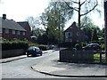
1
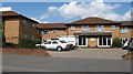
Servite Care Home, Glenavon Road
Where once stood St Judes Catholic Church (until 70s), now stands one of many Servite homes. http://www.housingcare.org/housing-care/facility-info-80305-servite-court-highters-heath-england.aspx
Image: © Michael Westley
Taken: 27 May 2010
0.10 miles
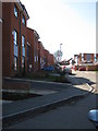
2
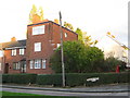
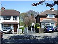
Unusual design residences
Half way down Glenavon Road is Denholme Grove
Image: © Michael Westley
Taken: 21 Oct 2010
0.12 miles
3
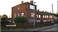
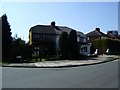
One of a pair, Denholm Grove
Half way down Glenavon Road, 2 distinctive 3 storey homes/flats on corner of Denholm Grove (cul-de-sac)
Image: © Michael Westley
Taken: 21 Oct 2010
0.14 miles
4
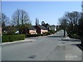
Glenavon Road, Maypole
Near junction with Littlecote Croft on right, and Grendon Road on left
Image: © Michael Westley
Taken: 23 Apr 2010
0.17 miles
5
Littlecote Croft, Maypole
Cul-de-sac between Glenavon Road and Sladepool Farm Road - a gulley (in background) gives pedestrian access between the two roads
Image: © Michael Westley
Taken: 23 Apr 2010
0.19 miles
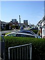
6
Whitlock Grove, Maypole
New housing development 'The Edge' on high ground, just off Warstock Road
http://www.smartnewhomes.com/development/details/The_Edge_Lovell_Partnerships_%28Midlands%29.aspx
Image: © Michael Westley
Taken: 7 Mar 2011
0.20 miles
7
Sladepool Farm Road, Maypole
View up towards Druids Heath Estate (blocks of flats in background) from gulley near Henlow Road.
Image: © Michael Westley
Taken: 23 Apr 2010
0.20 miles
8
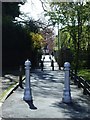
The Gulley, Littlecote Croft
Pedestrian link between Sladepool Farm Road and Glenavon Road - original posts, preventing large vehicular use; more recently now has additional 'defences' either end, preventing motorcycle access.
Image: © Michael Westley
Taken: 23 Apr 2010
0.20 miles
9
Gully on Sladepool Farm Road
Gully towards Littlecoat Croft - with ugly anti-motorcycle bars
Image: © Michael Westley
Taken: 23 Apr 2010
0.20 miles
10
Overgrown, Henlow Road, Maypole
Overgrown semi-detached, on corner of Henlow Road and Sladepool Farm Road
Image: © Michael Westley
Taken: 23 Apr 2010
0.22 miles