IMAGES TAKEN NEAR TO
Anderton Park Road, BIRMINGHAM, B13 9DS
Introduction
This page details the photographs taken nearby to Anderton Park Road, B13 9DS by members of the Geograph project.
The Geograph project started in 2005 with the aim of publishing, organising and preserving representative images for every square kilometre of Great Britain, Ireland and the Isle of Man.

There are currently over 7.5m images from over14,400 individuals and you can help contribute to the project by visiting https://www.geograph.org.uk
Image Map
Images are licensed for reuse under creativecommons.org/licenses/by-sa/2.0
Notes
- Clicking on the map will re-center to the selected point.
- The higher the marker number, the further away the image location is from the centre of the postcode.
Image Listing (36 Images Found)
Images are licensed for reuse under creativecommons.org/licenses/by-sa/2.0
Image
Details
Distance
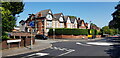
1
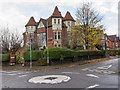
Large detached house
This very large house was on the corner of Forest Road and Anderton Park Road.
Image: © David P Howard
Taken: 22 Nov 2012
0.06 miles
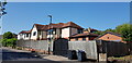
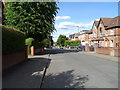
2
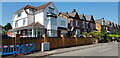
Houses on Anderton Park Road and Sandford Road
The house seen to the left occupies the corner plot at the crossroads.
Image: © Paul Collins
Taken: 14 Jun 2023
0.06 miles
3
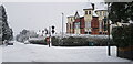
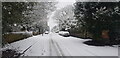
Anderton Park Road in Snow
A Sunday morning, snow and a Coronavirus lockdown combine to reduce traffic almost to zero, making for unusually good conditions for a walk. Forest Road crosses left to right.
Image: © Paul Collins
Taken: 24 Jan 2021
0.06 miles
4
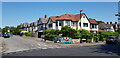
Houses on Anderton Park Road and Sandford Road
Number 62 Anderton Park Road (the house on the right) has been greatly extended and remodelled. Works to resurface Anderton Park Road are nearing completion.
Image: © Paul Collins
Taken: 14 Jun 2023
0.08 miles
5
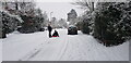
Anderton Park Road in Snow
A Sunday morning, snow and a Coronavirus lockdown combine to reduce traffic almost to zero, making for unusually quiet conditions for a walk.
Image: © Paul Collins
Taken: 24 Jan 2021
0.08 miles
6
62 Anderton Park Road
Number 62 Anderton Park Road has been greatly remodelled and extended. Works to resurface Anderton Park Road are nearing completion.
Image: © Paul Collins
Taken: 14 Jun 2023
0.09 miles
7
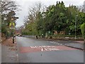
School Zone
Looking NNW along Forest Road towards the junction with Oakland Road. The School Zone painted onto the road surface, and the traffic calming measures relate to the school that is behind the trees and fencing in the background.
It is St. Martin de Porres, voluntary aided Roman Catholic Primary School. http://www.stmartindeporres.org.uk/
Image: © David P Howard
Taken: 22 Nov 2012
0.11 miles
8
Anderton Park Road in Snow
A Sunday morning, snow and a Coronavirus lockdown combine to reduce traffic almost to zero, making for unusually quiet conditions for fun in the snow.
Image: © Paul Collins
Taken: 24 Jan 2021
0.13 miles
10
Houses in Anderton Park Road
Works to resurface Anderton Park Road are nearing completion. Queenswood Road is seen running off to the left.
Image: © Paul Collins
Taken: 14 Jun 2023
0.14 miles