IMAGES TAKEN NEAR TO
St. Albans Road, BIRMINGHAM, B13 9AS
Introduction
This page details the photographs taken nearby to St. Albans Road, B13 9AS by members of the Geograph project.
The Geograph project started in 2005 with the aim of publishing, organising and preserving representative images for every square kilometre of Great Britain, Ireland and the Isle of Man.

There are currently over 7.5m images from over14,400 individuals and you can help contribute to the project by visiting https://www.geograph.org.uk
Image Map
Images are licensed for reuse under creativecommons.org/licenses/by-sa/2.0
Notes
- Clicking on the map will re-center to the selected point.
- The higher the marker number, the further away the image location is from the centre of the postcode.
Image Listing (31 Images Found)
Images are licensed for reuse under creativecommons.org/licenses/by-sa/2.0
Image
Details
Distance
1
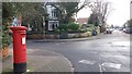
Post Box in Sandford Road at Junction with Church Road
Image: © Paul Collins
Taken: 7 Jan 2018
0.09 miles
3
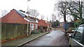
Sarehole Mill Gardens
Sarehole Mill Gardens is a short, straight cul de sac off Trafalgar Road which terminates at the railway. On the left hand side are three identical two-storey detached houses all built about 2004. But for some reason, at the time of photographing, they have been partially demolished and are seemingly semi-abandoned and open to the elements.
Image: © Paul Collins
Taken: 1 Feb 2017
0.11 miles
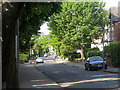
4

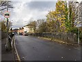
Railway line from Woodbridge Road
Looking north from the railway bridge on Woodbridge Road.
Image: © David P Howard
Taken: 22 Nov 2012
0.13 miles
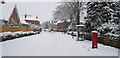
5
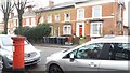
Victorian Pillar Box and Houses in Trafalgar Road
The northern end of Trafalgar Road boasts some fine Victorian houses and this VR-ciphered pillar box opposite Sarehole Mill Gardens. Unfortunately many of the properties have been subdivided and some are neglected. This group seems so far to have escaped serious disfigurement.
Image: © Paul Collins
Taken: 1 Feb 2017
0.14 miles
6

47 Woodbridge Road, Moseley
Built around 1851, and Grade II listed https://britishlistedbuildings.co.uk/101076066-47-woodbridge-road-see-details-for-further-address-information-moseley-and-kings-heath-ward#.W9a7T0v7RPY in 1982. The property was originally built as a schoolmaster's house, and was linked to the former boarding school, which is partially in-shot to the right, a little further along Church Road.
Image: © Richard Law
Taken: 12 Sep 2018
0.16 miles
7
Railway bridge, Woodbridge Road
Looking WNW along Woodbridge Road over the railway bridge, towards the row of shops on the far side.
Image: © David P Howard
Taken: 22 Nov 2012
0.17 miles
8
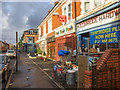
Bish Bash Bosh!
A row of shops on Woodbridge Road.
Image: © David P Howard
Taken: 22 Nov 2012
0.18 miles
9
Forest Road in Snow
A Sunday morning, snow and a Coronavirus lockdown combine to reduce traffic almost to zero, making for unusually good conditions for a walk.
Image: © Paul Collins
Taken: 24 Jan 2021
0.18 miles
10
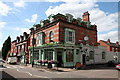
Patrick Kavanagh (nee Trafalgar) Pub
The Patrick Kavanagh public house was originally called the Trafalgar. It is on the junction of Trafalgar Road and Woodbridge Road.
Image: © Brendan Patchell
Taken: 24 Jul 2006
0.18 miles