IMAGES TAKEN NEAR TO
Tilbury Grove, BIRMINGHAM, B13 8PE
Introduction
This page details the photographs taken nearby to Tilbury Grove, B13 8PE by members of the Geograph project.
The Geograph project started in 2005 with the aim of publishing, organising and preserving representative images for every square kilometre of Great Britain, Ireland and the Isle of Man.

There are currently over 7.5m images from over14,400 individuals and you can help contribute to the project by visiting https://www.geograph.org.uk
Image Map
Images are licensed for reuse under creativecommons.org/licenses/by-sa/2.0
Notes
- Clicking on the map will re-center to the selected point.
- The higher the marker number, the further away the image location is from the centre of the postcode.
Image Listing (17 Images Found)
Images are licensed for reuse under creativecommons.org/licenses/by-sa/2.0
Image
Details
Distance
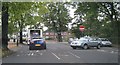
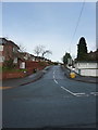
1
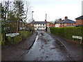
Tilbury Grove. Moor Green
A view up the quiet cul-de-sac of Tilbury Grove
Image: © Richard Law
Taken: 16 Dec 2019
0.00 miles
3
Highbury Park, Kings Heath
View of trail through trees, looking across park towards Shutlock Lane.
http://highburyparkfriends.org.uk/wp/?page_id=7
Image: © Michael Westley
Taken: 17 Mar 2011
0.09 miles
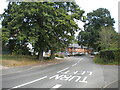
5
Dad's Lane / Shutlock Lane junction
Entrance to Highbury Park is just a short distance along Shutlock Lane on the right (beyond where cars are coming out). The railway bridge is just behind the photographer's position.
Image: © Michael Westley
Taken: 15 Oct 2010
0.14 miles
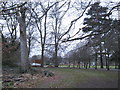
6
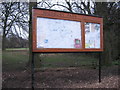
Distinguished Notice Board, Highbury Park
Alongside the car park, accessed from Dads Lane, is a very distinguished wooden noticeboard with extensive map of trails around this beautiful park, north of Kings Heath.
https://highburyparkfriends.org.uk/wp/about-highbury-park/visiting-highbury-park/
Image: © Michael Westley
Taken: 17 Mar 2011
0.15 miles
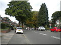
7
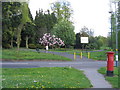
Highbury Park, Moor Green Lane Entrance & Pillar Box
Just where Moor Green Lane and Shuttlock Road meet.
Image: © Roy Hughes
Taken: 25 Apr 2009
0.16 miles
8
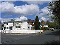
Art Deco House, Corner Moor Green Lane & Elizabeth Road, Moseley
Image: © Roy Hughes
Taken: 25 Apr 2009
0.17 miles
9
Looking up Elizabeth Road from Dogpool Lane
Image: © Richard Law
Taken: 16 Dec 2019
0.20 miles
10
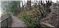
Dad's Lane Pavement with Midland Railway Marker Post
This is the view down Dad's Lane from the railway bridge, taken on a gloomy midwinter's day. Highbury Park is at the top of the bank and because there are no steps at this point people risk a fall ascending or descending the slippery bank. The MR on the metal marker post is presumably a boundary marker signifying 'Midland Railway', so it presumably dates to before amalgamation in 1922.
Image: © Paul Collins
Taken: 26 Dec 2021
0.20 miles