IMAGES TAKEN NEAR TO
Sutherland Drive, BIRMINGHAM, B13 8AY
Introduction
This page details the photographs taken nearby to Sutherland Drive, B13 8AY by members of the Geograph project.
The Geograph project started in 2005 with the aim of publishing, organising and preserving representative images for every square kilometre of Great Britain, Ireland and the Isle of Man.

There are currently over 7.5m images from over14,400 individuals and you can help contribute to the project by visiting https://www.geograph.org.uk
Image Map
Images are licensed for reuse under creativecommons.org/licenses/by-sa/2.0
Notes
- Clicking on the map will re-center to the selected point.
- The higher the marker number, the further away the image location is from the centre of the postcode.
Image Listing (26 Images Found)
Images are licensed for reuse under creativecommons.org/licenses/by-sa/2.0
Image
Details
Distance
1
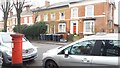
Victorian Pillar Box and Houses in Trafalgar Road
The northern end of Trafalgar Road boasts some fine Victorian houses and this VR-ciphered pillar box opposite Sarehole Mill Gardens. Unfortunately many of the properties have been subdivided and some are neglected. This group seems so far to have escaped serious disfigurement.
Image: © Paul Collins
Taken: 1 Feb 2017
0.07 miles
2
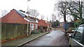
Sarehole Mill Gardens
Sarehole Mill Gardens is a short, straight cul de sac off Trafalgar Road which terminates at the railway. On the left hand side are three identical two-storey detached houses all built about 2004. But for some reason, at the time of photographing, they have been partially demolished and are seemingly semi-abandoned and open to the elements.
Image: © Paul Collins
Taken: 1 Feb 2017
0.09 miles
3
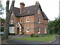
Grevis Close
Home on corner of Trafalgar Road and Grevis Close, Moseley
Image: © Michael Westley
Taken: 2 Jun 2011
0.09 miles
4
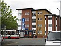
Flats, Alcester Road, Balsall Heath
Flats opposite Edgbaston Road, on main Alcester Road, also opposite unused former bus garage
Image: © Michael Westley
Taken: 14 May 2010
0.12 miles
5
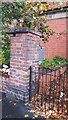
Benchmark on Brick Pillar in Trafalgar Road
This benchmark is cut into the blue bricks at the base of the pillar at the east end of the Creation Climbing Centre. It was verified by the Ordnance Survey in 1965 at 132.5667 metres above sea level. The Creation centre is a fantastic venue offering excellent indoor facilities for rock climbing and other activities like scooting and indoor caving. The building it occupies is shabby but in my opinion of great architectural merit and historic interest, having been built as a tram depot.
Image: © Paul Collins
Taken: 30 Sep 2017
0.12 miles
6
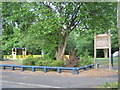
Small Recreation Area, Moseley
Hidden away on Trafalgar Road, near Fenter Close
Image: © Michael Westley
Taken: 2 Jun 2011
0.13 miles
7
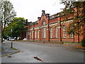
The Tram Depot (The Old Bus Depot) - view from Trafalgar Road at junction with Rushbrooke Close.
Image: © J Taylor
Taken: 22 Sep 2008
0.13 miles
9
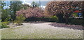
Blossom at Park Hill School
The trees are pictured on a day when the school was closed and in use as a polling station for elections for the police and crime commissioner and the combined mayoral authority.
Image: © Paul Collins
Taken: 6 May 2021
0.14 miles
10
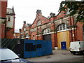
The Tram Depot (The Old Bus Depot) - view from Trafalgar Road at junction with Alcester Road
Image: © J Taylor
Taken: 22 Sep 2008
0.15 miles