IMAGES TAKEN NEAR TO
Wheelers Lane, BIRMINGHAM, B13 0ST
Introduction
This page details the photographs taken nearby to Wheelers Lane, B13 0ST by members of the Geograph project.
The Geograph project started in 2005 with the aim of publishing, organising and preserving representative images for every square kilometre of Great Britain, Ireland and the Isle of Man.

There are currently over 7.5m images from over14,400 individuals and you can help contribute to the project by visiting https://www.geograph.org.uk
Image Map
Images are licensed for reuse under creativecommons.org/licenses/by-sa/2.0
Notes
- Clicking on the map will re-center to the selected point.
- The higher the marker number, the further away the image location is from the centre of the postcode.
Image Listing (16 Images Found)
Images are licensed for reuse under creativecommons.org/licenses/by-sa/2.0
Image
Details
Distance
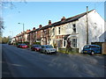
1
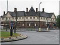
The New Billesley pub
Pub on corner of Brook Lane and Wheelers Lane, Kings Heath - opposite Swanshurst School
Image: © Michael Westley
Taken: 1 Jun 2010
0.06 miles
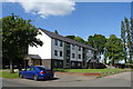
2
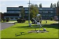
Swanshurst School
Now a specialist science college the school started as Swanshurst Technical Modern School for Girls.
Image: © John M
Taken: 6 Oct 2013
0.06 miles
3
Swanshurst School
Once a Grammar School (for girls only I think), situated at corner of Wheelers Lane and Brook Lane, Kings Heath
Image: © Michael Westley
Taken: 1 Jun 2010
0.06 miles
6
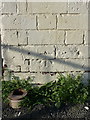
OS benchmark - Billesley, 198 Brook Lane
In a rather poor condition, but still recognisable for what it was; this OS cutmark was originally levelled, probably in 1965, at 147.011m above Ordnance Datum Newlyn.
Image: © Richard Law
Taken: 18 Apr 2018
0.10 miles
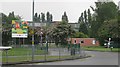
8
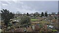
NEW
Wheelers Lane Allotments
This allotment site is quite hidden away behind the houses that front the triangle of roads that surround the site. They were laid out between the two world wars when the houses on Wheeler's Lane, Barn Lane and the western end of Brook Lane were built.
Image: © Paul Collins
Taken: 24 Feb 2025
0.15 miles
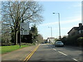
10
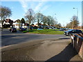
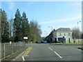
Roundabout on Wheeler's Lane
At the point where Wheeler's Lane crosses Hollybank Road (off to the right) and Barn Lane (to the left).
Image: © Richard Law
Taken: 18 Apr 2018
0.19 miles