IMAGES TAKEN NEAR TO
Wroxall Grove, BIRMINGHAM, B13 0RS
Introduction
This page details the photographs taken nearby to Wroxall Grove, B13 0RS by members of the Geograph project.
The Geograph project started in 2005 with the aim of publishing, organising and preserving representative images for every square kilometre of Great Britain, Ireland and the Isle of Man.

There are currently over 7.5m images from over14,400 individuals and you can help contribute to the project by visiting https://www.geograph.org.uk
Image Map
Images are licensed for reuse under creativecommons.org/licenses/by-sa/2.0
Notes
- Clicking on the map will re-center to the selected point.
- The higher the marker number, the further away the image location is from the centre of the postcode.
Image Listing (11 Images Found)
Images are licensed for reuse under creativecommons.org/licenses/by-sa/2.0
Image
Details
Distance
1
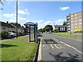
Bus stop and shelter on Hollybank Road, Birmingham
Image: © JThomas
Taken: 22 Jun 2019
0.08 miles
2
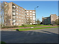
Kineton House, Hollybank Road
One of 6 identical blocks of flats lining the east side of Hollybank Road; the last of them (Ludlow House) is visible beyond.
Image: © Richard Law
Taken: 18 Apr 2018
0.09 miles
3
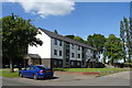
Woodstock House
Flats off Hollybank Road, Birmingham.
Image: © JThomas
Taken: 22 Jun 2019
0.09 miles
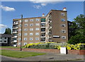
4
Woodstock House, Hollybank Road
A 6-storey block of flats on Hollybank Road; there are several more in the same style further along the road.
Image: © Richard Law
Taken: 18 Apr 2018
0.10 miles
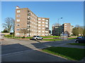
5
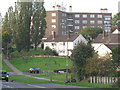
Ludlow House, Hollybank Road
View from road of houses and flats on hillside, that back onto Billesley Common, near Kings Heath
Image: © Michael Westley
Taken: 5 Oct 2010
0.12 miles
7
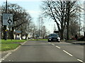
A4040 Wheelers Lane approaching Barn Lane island
Image: © Roy Hughes
Taken: 30 Mar 2021
0.18 miles
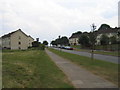
8
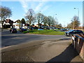
Roundabout on Wheeler's Lane
At the point where Wheeler's Lane crosses Hollybank Road (off to the right) and Barn Lane (to the left).
Image: © Richard Law
Taken: 18 Apr 2018
0.18 miles
9
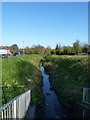
The Haunch Brook
Here the brook emerges from a culvert under Hollybank Road, and heads off towards Billesley Common, the wooded area in the background, where it joins the Chinn Brook. The Common was a huge area of open farmland on maps dating from the turn of the 19th century, but more than half of it has now been built over.
Image: © Richard Law
Taken: 18 Apr 2018
0.21 miles
10
Billesley Common
Billesley Common itself occupies the central part of this square, flanked on either side by housing and low rise flats in a district taking its name from the Common.
Image: © David Stowell
Taken: 2 Jul 2006
0.24 miles