IMAGES TAKEN NEAR TO
Clevedon Road, BIRMINGHAM, B12 9HD
Introduction
This page details the photographs taken nearby to Clevedon Road, B12 9HD by members of the Geograph project.
The Geograph project started in 2005 with the aim of publishing, organising and preserving representative images for every square kilometre of Great Britain, Ireland and the Isle of Man.

There are currently over 7.5m images from over14,400 individuals and you can help contribute to the project by visiting https://www.geograph.org.uk
Image Map
Images are licensed for reuse under creativecommons.org/licenses/by-sa/2.0
Notes
- Clicking on the map will re-center to the selected point.
- The higher the marker number, the further away the image location is from the centre of the postcode.
Image Listing (33 Images Found)
Images are licensed for reuse under creativecommons.org/licenses/by-sa/2.0
Image
Details
Distance
1
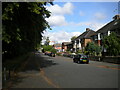
Rea Rea, Balsall Heath
Looking towards the city centre.
Image: © Roy Hughes
Taken: 18 Apr 2009
0.06 miles
2
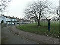
Cheddar Road and Calthorpe Park
The park was laid out in 1853, on land given by the Calthorpe family. The road and houses were built between 1889 and 1902, on the former route of the River Rea, after the river had been straightened and moved slightly west.
Image: © Christine Johnstone
Taken: 24 Jan 2023
0.07 miles
3
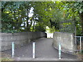
Footbridge across the River Rea, Highgate
Linking the two parts of Calthorpe Park.
Image: © Richard Vince
Taken: 9 Jul 2022
0.08 miles
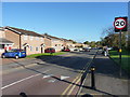
4
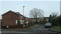
Minivet Drive, Balsall Heath
Off Court Road, just north of Siskin Drive. Both roads are named after birds that live in woodland - siskins in Europe and America, minivets in south and east Asia.
Image: © Christine Johnstone
Taken: 24 Jan 2023
0.10 miles
5

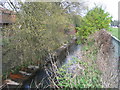
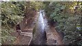
River Rea - artistic
The high retaining walls hiding the River Rea, between Calthorpe Park and Balsall Heath Road, are a canvas for graffiti artists, few people are likely to see.
The driftwood/rubbish hanging from the wall demonstrates perhaps a higher waterline at other times.
Image: © Michael Westley
Taken: 23 Oct 2016
0.11 miles
6
South end of Alexandra Road, Highgate
Alongside Calthorpe Park.
Image: © Richard Vince
Taken: 9 Jul 2022
0.11 miles
7
River Rea
River Rea runs in a culvert between Calthorpe Park
Image: © Shaun Ferguson
Taken: 22 Sep 2021
0.13 miles
9
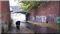
River Rea, Balsall Heath Road
Approaching the bridge carrying Balsall Heath Road across the River Rea.
Graffiti artists' paradise.
The wall on the right hides the high grass / parkland area alongside Clevedon Road
Image: © Michael Westley
Taken: 23 Oct 2016
0.16 miles
10
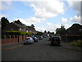
Lincoln Street, Balsall Heath
Relatively modern housing, probably 1970s era, lines either side of Lincoln Street
Image: © Richard Law
Taken: 17 Oct 2019
0.16 miles