IMAGES TAKEN NEAR TO
Ombersley Road, BIRMINGHAM, B12 8UZ
Introduction
This page details the photographs taken nearby to Ombersley Road, B12 8UZ by members of the Geograph project.
The Geograph project started in 2005 with the aim of publishing, organising and preserving representative images for every square kilometre of Great Britain, Ireland and the Isle of Man.

There are currently over 7.5m images from over14,400 individuals and you can help contribute to the project by visiting https://www.geograph.org.uk
Image Map
Images are licensed for reuse under creativecommons.org/licenses/by-sa/2.0
Notes
- Clicking on the map will re-center to the selected point.
- The higher the marker number, the further away the image location is from the centre of the postcode.
Image Listing (53 Images Found)
Images are licensed for reuse under creativecommons.org/licenses/by-sa/2.0
Image
Details
Distance

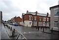
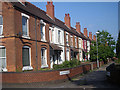
2

Highgate Rd Balsall Heath
View NW along Highgate Rd which runs from the Alcester Rd to the Stratford Rd between Sparkbrook and Balsall Heath.
Image: © Nigel Mykura
Taken: 28 Feb 2009
0.07 miles

7
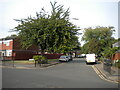
Turner Street, Sparkbrook
Off Ladypool Road.
Image: © Richard Vince
Taken: 3 Sep 2022
0.15 miles