IMAGES TAKEN NEAR TO
Brighton Road, BIRMINGHAM, B12 8QH
Introduction
This page details the photographs taken nearby to Brighton Road, B12 8QH by members of the Geograph project.
The Geograph project started in 2005 with the aim of publishing, organising and preserving representative images for every square kilometre of Great Britain, Ireland and the Isle of Man.

There are currently over 7.5m images from over14,400 individuals and you can help contribute to the project by visiting https://www.geograph.org.uk
Image Map
Images are licensed for reuse under creativecommons.org/licenses/by-sa/2.0
Notes
- Clicking on the map will re-center to the selected point.
- The higher the marker number, the further away the image location is from the centre of the postcode.
Image Listing (22 Images Found)
Images are licensed for reuse under creativecommons.org/licenses/by-sa/2.0
Image
Details
Distance
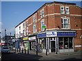
2
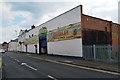
Shops and businesses on Ladypool Road, Balsall Heath
Image: © Richard Law
Taken: 17 Oct 2019
0.10 miles
3
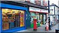
Church Road Post Office
This post office stands at the north end of Church Road on the corner with Newport Road. According to old Ordnance Survey maps there has been a post office on this site since at least 1903.
Image: © Paul Collins
Taken: 15 Dec 2016
0.10 miles
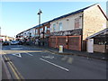
4
Birchwood Road
This road is lined by typical Victorian terraces. The steps lead up to Image behind the photographer.
Image: © David Stowell
Taken: 2 Jul 2006
0.16 miles
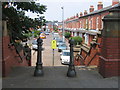
5

Birchwood Crescent
Looking the other way from the steps up from Image at this quiet tree (and car!) lined street.
Image: © David Stowell
Taken: 2 Jul 2006
0.16 miles
6

Site of Brighton Road Station, Birmingham
View eastward; ex-Midland Birmingham New St. etc.(left) - Kings Norton and the South (right) main line via Camp Hill. This line was the original main line from the south and has remained so for freight, but the local passenger service was withdrawn on 27/1/41, when this and other suburban stations were closed to passengers.
Image: © Ben Brooksbank
Taken: 5 Sep 1962
0.17 miles
7
A Boullah & Sons' Carpet Warehouse - Taunton Road frontage
Former Drill Hall for the 1 South Midland Mounted Brigade, Transport & Supply Column in 1914.
Image: © John M
Taken: 22 Jun 2014
0.17 miles
8
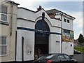
A Boullah & Sons' Carpet Warehouse - Dennis Road frontage
Former Drill Hall for the 1 South Midland Mounted Brigade, Transport & Supply Column in 1914.
Image: © John M
Taken: 22 Jun 2014
0.18 miles
9
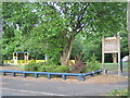
Small Recreation Area, Moseley
Hidden away on Trafalgar Road, near Fenter Close
Image: © Michael Westley
Taken: 2 Jun 2011
0.18 miles
10
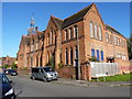
Former school buildings, Clifton Road
The area just behind this rather impressive (Victorian?) building is marked as "St Paul's School", part of the St Paul's Community Development Trust organisation, a charity which runs a couple of schools, a children's nursery, a city farm and other out-of-school activities. This building appears to be disused, in the sense that the main entrances and doorways are closed up and overgrown, although there may be internal accesses to it.
Image: © Richard Law
Taken: 17 Oct 2019
0.19 miles