IMAGES TAKEN NEAR TO
Darwin Street, BIRMINGHAM, B12 0TP
Introduction
This page details the photographs taken nearby to Darwin Street, B12 0TP by members of the Geograph project.
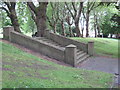
The Geograph project started in 2005 with the aim of publishing, organising and preserving representative images for every square kilometre of Great Britain, Ireland and the Isle of Man.

There are currently over 7.5m images from over14,400 individuals and you can help contribute to the project by visiting https://www.geograph.org.uk
Image Map
Images are licensed for reuse under creativecommons.org/licenses/by-sa/2.0
Notes
- Clicking on the map will re-center to the selected point.
- The higher the marker number, the further away the image location is from the centre of the postcode.
Image Listing (99 Images Found)
Images are licensed for reuse under creativecommons.org/licenses/by-sa/2.0
Image
Details
Distance
1
OS benchmark - Highgate, 154 Darwin Street
An OS cutmark on the SE-facing side of a terrace of houses on Darwin Street; originally levelled at 120.039m above Ordnance Datum Newlyn.
Image: © Richard Law
Taken: 28 Sep 2015
0.02 miles
2
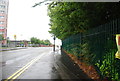
Ashford Tower, Highgate Park
Pedestrian entrance from Salop Street to quiet park on hillside in city centre and block of flats
Image: © Michael Westley
Taken: 11 May 2011
0.06 miles
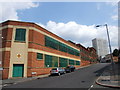
3
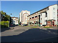
Flats off Darwin Street, Highgate Park
This is Shawbury Grove, a development of flats in the Highgate area of Birmingham.
Image: © Richard Law
Taken: 28 Sep 2015
0.10 miles
4
Highgate Park, Birmingham
Steps in grounds of hillside city park
Image: © Michael Westley
Taken: 11 May 2011
0.10 miles
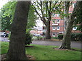
5
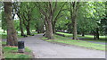
Highgate Park
A small jewel of the many city parks, hidden away in the trees, near inner city housing, just off Moseley Road, Highgate
Image: © Michael Westley
Taken: 11 May 2011
0.10 miles


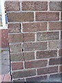
9
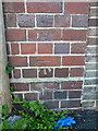
OS benchmark - Highgate, Darwin Street
An OS cutmark on a roadside wall on Darwin St; originally levelled at 111.66m above Ordnance Datum Newlyn.
Image: © Richard Law
Taken: 28 Sep 2015
0.10 miles