IMAGES TAKEN NEAR TO
Dymoke Street, BIRMINGHAM, B12 0TA
Introduction
This page details the photographs taken nearby to Dymoke Street, B12 0TA by members of the Geograph project.
The Geograph project started in 2005 with the aim of publishing, organising and preserving representative images for every square kilometre of Great Britain, Ireland and the Isle of Man.

There are currently over 7.5m images from over14,400 individuals and you can help contribute to the project by visiting https://www.geograph.org.uk
Image Map
Images are licensed for reuse under creativecommons.org/licenses/by-sa/2.0
Notes
- Clicking on the map will re-center to the selected point.
- The higher the marker number, the further away the image location is from the centre of the postcode.
Image Listing (86 Images Found)
Images are licensed for reuse under creativecommons.org/licenses/by-sa/2.0
Image
Details
Distance
2
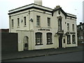
The Peacock
This pub is on the corner of Dymoke Street and Darwin Street.
Image: © Carl Baker
Taken: 14 Oct 2006
0.01 miles
3
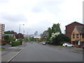
Leopold Street, Highgate
Looking north west.
Image: © JThomas
Taken: 6 May 2017
0.04 miles
4
Shop on Vaughton Street, Highgate, Birmingham
Showing position of Postbox No. B12 1412.
See Image] for postbox.
Image: © JThomas
Taken: 6 May 2017
0.05 miles
5
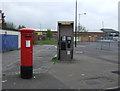
Edward VII postbox and telephone box on Vaughton Street, Highgate, Birmingham
Postbox No. B12 1412.
See Image] for postbox.
Image: © JThomas
Taken: 6 May 2017
0.06 miles
6
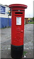
Edward VII postbox on Vaughton Street, Highgate, Birmingham
Image: © JThomas
Taken: 6 May 2017
0.06 miles
7
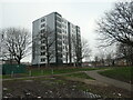
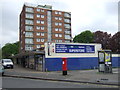
Refurbished tower block, off Charles Henry Street
Six years earlier, it looked like this Image In 1938 this was the site of the Albion Screw Works.
Image: © Christine Johnstone
Taken: 24 Jan 2023
0.08 miles
9
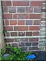
OS benchmark - Highgate, Darwin Street
An OS cutmark on a roadside wall on Darwin St; originally levelled at 111.66m above Ordnance Datum Newlyn.
Image: © Richard Law
Taken: 28 Sep 2015
0.09 miles
10
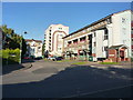
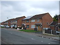
Flats off Darwin Street, Highgate Park
This is Shawbury Grove, a development of flats in the Highgate area of Birmingham.
Image: © Richard Law
Taken: 28 Sep 2015
0.11 miles