IMAGES TAKEN NEAR TO
Rea Place, BIRMINGHAM, B12 0NJ
Introduction
This page details the photographs taken nearby to Rea Place, B12 0NJ by members of the Geograph project.
The Geograph project started in 2005 with the aim of publishing, organising and preserving representative images for every square kilometre of Great Britain, Ireland and the Isle of Man.

There are currently over 7.5m images from over14,400 individuals and you can help contribute to the project by visiting https://www.geograph.org.uk
Image Map
Images are licensed for reuse under creativecommons.org/licenses/by-sa/2.0
Notes
- Clicking on the map will re-center to the selected point.
- The higher the marker number, the further away the image location is from the centre of the postcode.
Image Listing (151 Images Found)
Images are licensed for reuse under creativecommons.org/licenses/by-sa/2.0
Image
Details
Distance
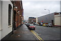
1
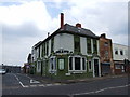
Dereliction on Bradford Street
Cracked like the House of Usher in Edgar Allan Poe's story, this building on Bradford Street in Highgate awaits the reconstruction that its neighbour to the left is undergoing, part of the gradual regeneration of this area of inner-city Birmingham.
Image: © A J Paxton
Taken: 22 Mar 2022
0.04 miles
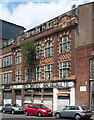
2
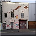
Derelict commercial building, Bradford Street, Birmingham
Another derelict building on Bradford Street awaits its saviour. It looks early 20th century; its striped 'Moorish' arches and chequerboard banding closely resemble those on Crowngate House on Great Hampton Street, which was built in 1913 (see the Historic England listing here https://historicengland.org.uk/listing/the-list/list-entry/1075542?section=comments-and-photos ; the Bradford Street property is not a listed building).
Image: © A J Paxton
Taken: 22 Mar 2022
0.06 miles
3
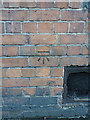
OS benchmark - Highgate, St Anne's Hostel
AN OS cutmark on the wall of the former Corporation Hostel, now St Anne's Hostel, in Moseley Street; originally levelled at 117.4m above Ordnance Datum Newlyn.
Image: © Richard Law
Taken: 28 Sep 2015
0.06 miles

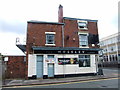
6
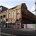
234-236 Bradford Street, Birmingham
One of numerous derelict industrial buildings hereabouts. This was the Englands shoe factory, built in 1913 by F.H. Thomason.
Its decline has continued for at least another seven years Image
Image: © Stephen Richards
Taken: 23 Jun 2015
0.06 miles
7

New buildings, Cheapside
View from Moseley Road, at top of Moseley Street, of buildings constructed in the last 5 years. The blue building is on Cheapside near junction with Moseley Road.
The land on left is awaiting further developments.
Image: © Michael Westley
Taken: 11 May 2011
0.07 miles
9
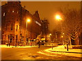
Snow in Birmingham 2009
A snowy night near Birmingham City Centre in February 2009
Image: © Andrew Tryon
Taken: 2 Feb 2009
0.08 miles