IMAGES TAKEN NEAR TO
Suffolk Street Queensway, BIRMINGHAM, B1 1LN
Introduction
This page details the photographs taken nearby to Suffolk Street Queensway, B1 1LN by members of the Geograph project.
The Geograph project started in 2005 with the aim of publishing, organising and preserving representative images for every square kilometre of Great Britain, Ireland and the Isle of Man.

There are currently over 7.5m images from over14,400 individuals and you can help contribute to the project by visiting https://www.geograph.org.uk
Image Map
Images are licensed for reuse under creativecommons.org/licenses/by-sa/2.0
Notes
- Clicking on the map will re-center to the selected point.
- The higher the marker number, the further away the image location is from the centre of the postcode.
Image Listing (1117 Images Found)
Images are licensed for reuse under creativecommons.org/licenses/by-sa/2.0
Image
Details
Distance
1
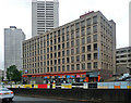
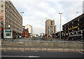
Kensington House, Suffolk Street Queensway, Birmingham
An undistinguished office block, possibly the work of James A. Roberts, 1972-74, who was responsible, with the city council, for the two towers behind, 1968-71. They are known collectively as the Sentinels.
Image: © Stephen Richards
Taken: 26 Aug 2011
0.01 miles
2
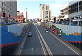
Suffolk Street, Queensway
Facing panels bring a splash of colour for drivers on Birmingham's Inner Ring Road.
Image: © John M
Taken: 1 May 2008
0.01 miles
3
Suffolk St Queensway from Gough Street, Birmingham
Central Birmingham looking down from Gough Street.
Image: © Stephen McKay
Taken: 3 Aug 2022
0.02 miles
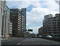
5
Suffolk Street Queensway (A38) seen from Holloway Circus, Birmingham
Image: © habiloid
Taken: 2 Mar 2013
0.03 miles
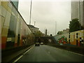
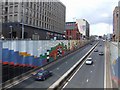
6
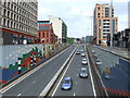
Suffolk Street Queensway (A38), Birmingham
The A38 trunk road descending into an underpass beneath Holloway Circus, in central Birmingham.
Image: © Malc McDonald
Taken: 13 Jun 2010
0.03 miles
7
Emerging From Queensway Tunnel, A38 Southbound
Image: © Roy Hughes
Taken: 6 May 2009
0.04 miles
8
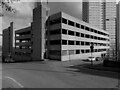
Brutalist Brum: Ellis Street multistorey car park
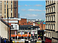
The Holloway Head district of central Birmingham suffered heavy damage in the second world war and was redeveloped in the 1960s and 70s in an uncompromisingly modern style. This photo of the Ellis Street multistorey car park was taken from Gough Street, with Ellis Street branching off to the right.
In the background can be seen the Sentinels, two 90m, 31-storey blocks of council flats designed by C Bryant & Son; Cleveland Tower was completed in 1970 and Clydesdale Tower in 1971. They have their own Wikipedia article here https://en.wikipedia.org/wiki/The_Sentinels , which describes their unusual history.
Brutalism is defined by the Royal Institute of British Architects (RIBA) as 'a style with an emphasis on materials, textures and construction, producing highly expressive forms.' https://www.architecture.com/explore-architecture/brutalism . This style, popular with architects (though not with the general public) from the 1950s through to the 1970s, was characterised by the use of 'beton brut' (raw concrete), its surface exposed and textured with the patterns of the wooden shuttering into which the concrete was poured.
Image: © A J Paxton
Taken: 5 Mar 2022
0.04 miles