IMAGES TAKEN NEAR TO
Fulham Road, BIRMINGHAM, B11 4QG
Introduction
This page details the photographs taken nearby to Fulham Road, B11 4QG by members of the Geograph project.
The Geograph project started in 2005 with the aim of publishing, organising and preserving representative images for every square kilometre of Great Britain, Ireland and the Isle of Man.

There are currently over 7.5m images from over14,400 individuals and you can help contribute to the project by visiting https://www.geograph.org.uk
Image Map
Images are licensed for reuse under creativecommons.org/licenses/by-sa/2.0
Notes
- Clicking on the map will re-center to the selected point.
- The higher the marker number, the further away the image location is from the centre of the postcode.
Image Listing (26 Images Found)
Images are licensed for reuse under creativecommons.org/licenses/by-sa/2.0
Image
Details
Distance
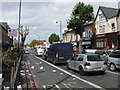
4
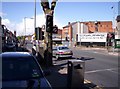
Stratford Road, Sparkbrook, Birmingham
At this point Stratford Road is also the A34. The junction with Warwick Road (the A41) is visible on the right, below a poster from the general election campaign that culminated three days previously. This area has a large Pakistani population and there are a large number of shops on Stratford Road serving that community.
Image: © Tom Pullman
Taken: 8 May 2005
0.07 miles
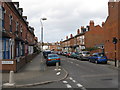
5

Stratford Road, Sparkhill
Looking towards Birmingham city centre from the junction with Weatheroak Road.
Image: © Richard Vince
Taken: 3 Sep 2022
0.13 miles
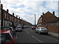
6
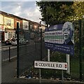
Nelson Mandela School, corner of Colville Road & Stoney Lane, Sparkbrook
Nelson Mandela School in Birmingham welcomed its first children in 1987, and was officially opened by Archbishop Desmond Tutu of Cape Town the following year. Mandela was at that time a prisoner in South Africa. He had been detained by the South African authorities in 1962 for leading resistance to the apartheid system of White supremacist rule in his country.
Mandela visited the school on the 11th October 1993. He had been released from prison in 1990 and as President of the African National Congress party was negotiating the end of apartheid with the government. The following year he was to become President of the Republic of South Africa, the country's first head of state from its Black African majority, having been elected in the country's first multiracial elections.
See Wikipedia https://en.m.wikipedia.org/wiki/Nelson_Mandela and the school site
https://www.nelsonmandelaschool.co.uk/our-school/our-history .
Image: © A J Paxton
Taken: 5 Oct 2024
0.13 miles
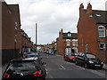
8
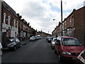
Wilton Road, Sparkhill
Off Stratford Road.
Image: © Richard Vince
Taken: 3 Sep 2022
0.13 miles
9

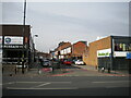
Surf'n'Turf: The Mermaid reborn as Farro's
The Mermaid was a Victorian pub on a prominent triangular site in Sparkhill where the Warwick & Stratford Roads fork. Old photos show an edifice with a pair of octagonal spirelets, later replaced by the neoclassical building visible here, though its Victorian wings survive to either side. It had a parapet with a relief of a mermaid by the local artist William Bloye, which was sadly lost some time after the pub closed and was then gutted by fire in 2010. See the Lost Pubs Project site https://www.closedpubs.co.uk/warwickshire/birmingham_b11_mermaid.html , which mentions the important role this pub played for the Irish community in Birmingham in the mid 20th century as a place where men could meet and find work, including unregistered labouring jobs 'on the lump'. Richard Vinen discusses this in his chapter on the Birmingham Irish in 'Second City: Birmingham and the Forging of Modern Britain', Allen Lane, 2022.
On the Mermaid's 1980s life as a music venue, a hub of anarcho-punk, metal and emerging grindcore, see Sarah Lafford's post at the Historic England blog https://heritagecalling.com/2024/08/30/at-the-mermaid-punk-metal-and-grindcore-in-1980s-birmingham/ , also Harry Sword at the Guardian https://www.theguardian.com/music/2023/jul/11/the-brummie-pub-that-birthed-grindcore-the-mermaid-sparkhill and the BBC site https://www.bbc.co.uk/news/articles/ckgw45204wwo.amp .
Image: © A J Paxton
Taken: 5 Oct 2024
0.13 miles