IMAGES TAKEN NEAR TO
Mackenzie Road, BIRMINGHAM, B11 4EP
Introduction
This page details the photographs taken nearby to Mackenzie Road, B11 4EP by members of the Geograph project.
The Geograph project started in 2005 with the aim of publishing, organising and preserving representative images for every square kilometre of Great Britain, Ireland and the Isle of Man.

There are currently over 7.5m images from over14,400 individuals and you can help contribute to the project by visiting https://www.geograph.org.uk
Image Map
Images are licensed for reuse under creativecommons.org/licenses/by-sa/2.0
Notes
- Clicking on the map will re-center to the selected point.
- The higher the marker number, the further away the image location is from the centre of the postcode.
Image Listing (28 Images Found)
Images are licensed for reuse under creativecommons.org/licenses/by-sa/2.0
Image
Details
Distance

4
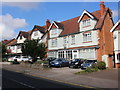
Houses in College Rd
These large red brick Victorian semi-detached houses are on the north side of College Rd. Often these large houses have been split up into multiple occupation. The closest house (No. 136) is called Fairview, even though it just looks across at another row of red brick Victorian houses.
Image: © Nigel Mykura
Taken: 1 Sep 2017
0.08 miles
10
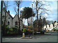
Corner of Hayfield Road and Wake Green Road
Araucaria araucana
Image: © araucaria araucana
Taken: 9 Mar 2009
0.13 miles