IMAGES TAKEN NEAR TO
Delta Way, BIRMINGHAM, B11 3NF
Introduction
This page details the photographs taken nearby to Delta Way, B11 3NF by members of the Geograph project.
The Geograph project started in 2005 with the aim of publishing, organising and preserving representative images for every square kilometre of Great Britain, Ireland and the Isle of Man.

There are currently over 7.5m images from over14,400 individuals and you can help contribute to the project by visiting https://www.geograph.org.uk
Image Map
Images are licensed for reuse under creativecommons.org/licenses/by-sa/2.0
Notes
- Clicking on the map will re-center to the selected point.
- The higher the marker number, the further away the image location is from the centre of the postcode.
Image Listing (9 Images Found)
Images are licensed for reuse under creativecommons.org/licenses/by-sa/2.0
Image
Details
Distance
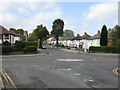
2
Olton Boulevard West
Looking north west to the junction with Reddings Lane.
Image: © JThomas
Taken: 6 May 2017
0.13 miles
3

Edward VII postbox on Reddings Lane, Tyseley, Birmingham
Postbox No. B11 209.
Image: © JThomas
Taken: 6 May 2017
0.13 miles
4
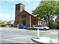
St Edmunds, Tyseley
The Church of England parish church of Tyseley in east Birmingham.
Image: © Richard Law
Taken: 15 May 2015
0.16 miles
6
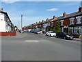
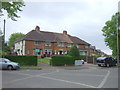
Medina Road, Tyseley
Terraced housing at the corner with Boscombe Road.
Image: © Richard Law
Taken: 15 May 2015
0.21 miles
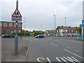
7
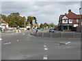
Cateswell Road looking north from Spring Road
Image: © Peter Whatley
Taken: 12 Sep 2011
0.22 miles
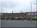
8
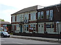
Tyseley and District Working Men's Club and Institute
Now incorporated as a Consumer Cooperative, the WMC was originally founded in 1923 as a members' club for local social events. It has an active membership, partaking in a variety of sporting pursuits (bowls, darts, snooker, etc) and provides a venue for gigs, weddings and the like.
Image: © Richard Law
Taken: 15 May 2015
0.24 miles
9
Spring Road crossed by Cateswell Road
Image: © Peter Whatley
Taken: 12 Sep 2011
0.24 miles