IMAGES TAKEN NEAR TO
Clarence Road, BIRMINGHAM, B11 3LD
Introduction
This page details the photographs taken nearby to Clarence Road, B11 3LD by members of the Geograph project.
The Geograph project started in 2005 with the aim of publishing, organising and preserving representative images for every square kilometre of Great Britain, Ireland and the Isle of Man.

There are currently over 7.5m images from over14,400 individuals and you can help contribute to the project by visiting https://www.geograph.org.uk
Image Map
Images are licensed for reuse under creativecommons.org/licenses/by-sa/2.0
Notes
- Clicking on the map will re-center to the selected point.
- The higher the marker number, the further away the image location is from the centre of the postcode.
Image Listing (28 Images Found)
Images are licensed for reuse under creativecommons.org/licenses/by-sa/2.0
Image
Details
Distance
2

Shell petrol station on the Stratford Road
Fuel prices were £1.329/litre for unleaded, and £1.369/litre for diesel in mid Sept 2018.
Image: © Richard Law
Taken: 12 Sep 2018
0.09 miles
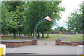
5

Sparkhill Pool and Fitness Centre (Closed)
Image: © N Chadwick
Taken: 11 Jun 2011
0.14 miles
6
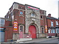
Factory
An unusual factory entrance in Evelyn Road which looks vaguely as though it may have had other uses over the years.
Image: © David Stowell
Taken: 2 Jul 2006
0.14 miles
8
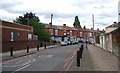
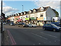
Stratford Road, Sparkhill
A typical row of urban shop fronts opposite the swimming baths.
Image: © David Stowell
Taken: 2 Jul 2006
0.15 miles

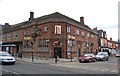
10
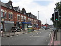
Shops and businesses on the Stratford Road, Sparkhill
At the junction with Formans Road
Image: © Richard Law
Taken: 12 Sep 2018
0.15 miles