IMAGES TAKEN NEAR TO
Briarfield Road, BIRMINGHAM, B11 3HL
Introduction
This page details the photographs taken nearby to Briarfield Road, B11 3HL by members of the Geograph project.
The Geograph project started in 2005 with the aim of publishing, organising and preserving representative images for every square kilometre of Great Britain, Ireland and the Isle of Man.

There are currently over 7.5m images from over14,400 individuals and you can help contribute to the project by visiting https://www.geograph.org.uk
Image Map
Images are licensed for reuse under creativecommons.org/licenses/by-sa/2.0
Notes
- Clicking on the map will re-center to the selected point.
- The higher the marker number, the further away the image location is from the centre of the postcode.
Image Listing (36 Images Found)
Images are licensed for reuse under creativecommons.org/licenses/by-sa/2.0
Image
Details
Distance
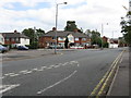
2
Briarfield Road, Acocks Green
Off Spring Road.
Image: © JThomas
Taken: 6 May 2017
0.01 miles
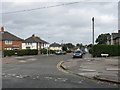
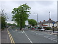
4
Briarfield Road, Tyseley
Briarfield Road leads off Spring Road and is seen here at the junction with Yarnfield Road and Sunningdale Road. A recent burst of heavy rain has ended and the heavy clods are clearing to reveal blue sky.
Image: © Stephen McKay
Taken: 21 Dec 2015
0.03 miles
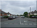
5
Spring Road meets Olton Boulevard West
Olton Boulecard West flows straight into Spring Road, with a continuation west of Spring Road leaving at a narrow angle. The diverging road's centre lane marking is somewhat optimistic.
Image: © Peter Whatley
Taken: 12 Sep 2011
0.03 miles
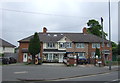
7
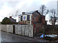
Derelict building - Spring Road
This building has clearly seen better days; the sign says 'Din's Fish and Chips Kebabs' but it must be a long time since it traded as such.
Image: © Stephen McKay
Taken: 21 Dec 2015
0.04 miles
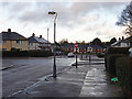
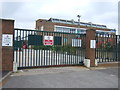
8
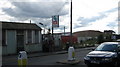
Spring Road, Acocks Green
Looking north west.
Image: © JThomas
Taken: 6 May 2017
0.05 miles
9
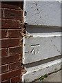
OS benchmark - Acocks Green, 338 Oulton Boulevard
An OS cutmark on one of the foundation stones of house number 338; originally levelled at 127.34m above Ordnance Datum Newlyn.
Image: © Richard Law
Taken: 15 May 2015
0.08 miles
10
Going, going, GONE
More sky in view at this city railway station, Spring Road. The pile of rubble is the remains of the landmark Lucas site that provided many more travellers for this station between Tyseley and Hall Green. Even the ticket office (shack on left) has been replaced (but still stands, possibly listed ?) - as it was Image]
Image: © Michael Westley
Taken: 13 Jun 2011
0.10 miles