IMAGES TAKEN NEAR TO
Cateswell Road, BIRMINGHAM, B11 3DZ
Introduction
This page details the photographs taken nearby to Cateswell Road, B11 3DZ by members of the Geograph project.
The Geograph project started in 2005 with the aim of publishing, organising and preserving representative images for every square kilometre of Great Britain, Ireland and the Isle of Man.

There are currently over 7.5m images from over14,400 individuals and you can help contribute to the project by visiting https://www.geograph.org.uk
Image Map
Images are licensed for reuse under creativecommons.org/licenses/by-sa/2.0
Notes
- Clicking on the map will re-center to the selected point.
- The higher the marker number, the further away the image location is from the centre of the postcode.
Image Listing (28 Images Found)
Images are licensed for reuse under creativecommons.org/licenses/by-sa/2.0
Image
Details
Distance
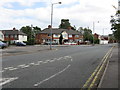
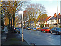
1

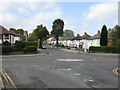
Cateswell Road, Tyseley
Semi-detached houses, probably dating from the 1930s, line the western side of Cateswell Road, seen here from Spring Road.
Image: © Stephen McKay
Taken: 21 Dec 2015
0.05 miles
2
Spring Road crossed by Cateswell Road
Image: © Peter Whatley
Taken: 12 Sep 2011
0.06 miles
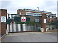
3
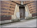
Unusual entrance design
Side entrance of the derelict Denso building in Hall Green (old Lucas Electrical).
Image: © Pete
Taken: 23 Jul 2008
0.10 miles
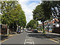
4
Cateswell Road looking north from Spring Road
Image: © Peter Whatley
Taken: 12 Sep 2011
0.10 miles
6
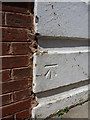
OS benchmark - Acocks Green, 338 Oulton Boulevard
An OS cutmark on one of the foundation stones of house number 338; originally levelled at 127.34m above Ordnance Datum Newlyn.
Image: © Richard Law
Taken: 15 May 2015
0.16 miles
7
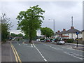
Spring Road, Acocks Green
Looking north west.
Image: © JThomas
Taken: 6 May 2017
0.16 miles
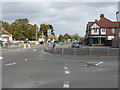
9
Spring Road meets Olton Boulevard West
Olton Boulecard West flows straight into Spring Road, with a continuation west of Spring Road leaving at a narrow angle. The diverging road's centre lane marking is somewhat optimistic.
Image: © Peter Whatley
Taken: 12 Sep 2011
0.19 miles
10
Cateswell Road, Hall Green
Seen from the Shaftmoor Lane Roundabout. The bus stop is served by route 40 operated by West Midlands Special Needs Transport.
Image: © Stephen McKay
Taken: 21 Dec 2015
0.19 miles