IMAGES TAKEN NEAR TO
Formans Road, BIRMINGHAM, B11 3BP
Introduction
This page details the photographs taken nearby to Formans Road, B11 3BP by members of the Geograph project.
The Geograph project started in 2005 with the aim of publishing, organising and preserving representative images for every square kilometre of Great Britain, Ireland and the Isle of Man.

There are currently over 7.5m images from over14,400 individuals and you can help contribute to the project by visiting https://www.geograph.org.uk
Image Map
Images are licensed for reuse under creativecommons.org/licenses/by-sa/2.0
Notes
- Clicking on the map will re-center to the selected point.
- The higher the marker number, the further away the image location is from the centre of the postcode.
Image Listing (6 Images Found)
Images are licensed for reuse under creativecommons.org/licenses/by-sa/2.0
Image
Details
Distance
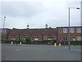
1

Art Deco Factory , Sparkhill
This factory now belongs to CBC in Forman's Rd . The view is from the end of Runnymede Rd. Forman's Rd runs from the Stratford Rd to Reddings Lane
Image: © Nigel Mykura
Taken: 28 Feb 2009
0.03 miles
2
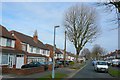
Runnymede Rd Sparkhill.
View north along this quiet residential street off Shaftmoor Lane
Image: © Nigel Mykura
Taken: 28 Feb 2009
0.14 miles
4
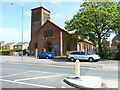
St Edmunds, Tyseley
The Church of England parish church of Tyseley in east Birmingham.
Image: © Richard Law
Taken: 15 May 2015
0.15 miles
5
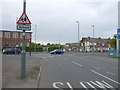
Olton Boulevard West
Looking north west to the junction with Reddings Lane.
Image: © JThomas
Taken: 6 May 2017
0.16 miles
6

Edward VII postbox on Reddings Lane, Tyseley, Birmingham
Postbox No. B11 209.
Image: © JThomas
Taken: 6 May 2017
0.19 miles