IMAGES TAKEN NEAR TO
Kyrwicks Lane, BIRMINGHAM, B11 1SS
Introduction
This page details the photographs taken nearby to Kyrwicks Lane, B11 1SS by members of the Geograph project.
The Geograph project started in 2005 with the aim of publishing, organising and preserving representative images for every square kilometre of Great Britain, Ireland and the Isle of Man.

There are currently over 7.5m images from over14,400 individuals and you can help contribute to the project by visiting https://www.geograph.org.uk
Image Map
Images are licensed for reuse under creativecommons.org/licenses/by-sa/2.0
Notes
- Clicking on the map will re-center to the selected point.
- The higher the marker number, the further away the image location is from the centre of the postcode.
Image Listing (68 Images Found)
Images are licensed for reuse under creativecommons.org/licenses/by-sa/2.0
Image
Details
Distance
1
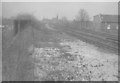
Site of Camp Hill and Balsall Heath Station
Looking north from site of former passenger station on the freight line (runs between Kings Norton and St Andrews junction near Bordesley).
This photo was taken from where the end of the north platform used to be. The building in the background (centre) is the then Teacher Training College on Stratford Road at Camp Hill Circus. House on right is on Montpellier Street.
Image: © Michael Westley
Taken: Unknown
0.05 miles
2
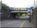
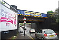
Railway bridge over Highgate Road (A4540)
Looking south east.
Image: © JThomas
Taken: 6 May 2017
0.08 miles
3
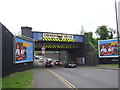
Railway bridge over Highgate Road (A4540)
Looking north west.
Image: © JThomas
Taken: 6 May 2017
0.08 miles
6
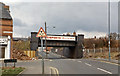
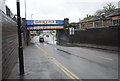
Site of Camp Hill station
The view is westward on Highgate Road at Woodfield Road (cf. Image]). Crossing is the original Midland Railway main line from Derby via Landor Street Junction and from Birmingham New Street via St Andrews Junction, to Kings Norton, Gloucester and Bristol. Camp Hill station was here on the left, served by a local service to/from New Street - Kings Norton, via the Lifford Curve and Selly Oak, until 27/1/41 when the station was closed to passengers. However the station remained open for goods until 7/2/66, while the line remained for the massive North/South freight traffic avoiding New Street. In recent years it also carries passenger trains on the NE/SW axis, which reverse in New Street.
Image: © Ben Brooksbank
Taken: 1 Apr 1984
0.09 miles
7
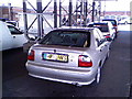
Birmingham Car Auctions
Birmingham Car Auctions. Vehicle Auctions including stolen/recovered. Address: 302-312 Moseley Road, Birmingham B12 0BS.
Image: © John Carver
Taken: 8 Apr 2008
0.09 miles
9
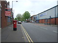
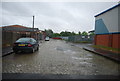
Moseley Road, Birmingham
Showing position of Postbox No. B12 47.
Image: © JThomas
Taken: 6 May 2017
0.11 miles
10
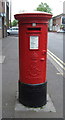
Edward VII postbox on Moseley Road, Birmingham
Postbox No. B12 47.
Image: © JThomas
Taken: 6 May 2017
0.11 miles