IMAGES TAKEN NEAR TO
Abbotsford Road, BIRMINGHAM, B11 1NU
Introduction
This page details the photographs taken nearby to Abbotsford Road, B11 1NU by members of the Geograph project.
The Geograph project started in 2005 with the aim of publishing, organising and preserving representative images for every square kilometre of Great Britain, Ireland and the Isle of Man.

There are currently over 7.5m images from over14,400 individuals and you can help contribute to the project by visiting https://www.geograph.org.uk
Image Map
Images are licensed for reuse under creativecommons.org/licenses/by-sa/2.0
Notes
- Clicking on the map will re-center to the selected point.
- The higher the marker number, the further away the image location is from the centre of the postcode.
Image Listing (31 Images Found)
Images are licensed for reuse under creativecommons.org/licenses/by-sa/2.0
Image
Details
Distance
1

Walford Road & Medlicott Road cross, Sparkhill
M J Nolan, purveyor of Twinings Fine Teas & Coffees, has given way to the Mughal General Stores, reflecting the shift over the years in Sparkhill from Irish settlement to South Asian, especially Pakistani. But Twinings still has pride of place at the street corner. To the left, the Hamza 24/7 Supermarket sports old-fashioned retractable awnings.
Image: © A J Paxton
Taken: 5 Oct 2024
0.14 miles
3
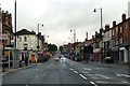
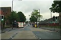
On Stratford Road at Sparkbrook
Opposite the new "Aldi" supermarket at Stratford Road Transport Exchange.
Image: © Neil Theasby
Taken: 18 Oct 2014
0.19 miles
4

Lebanese flag, Highgate Road, Sparkbrook
A large mosque in a modern architectural style is proposed for this triangular site bounded by Stratford Road, Highgate Road and Stoney Lane (of 'Balti Triangle' fame, a restaurant quarter now much in decline). In the meantime a Lebanese flag flies from a lamppost, in solidarity with Lebanon under heavy bombardment by Israel during Israeli-Hezbollah fighting in October 2024.
Image: © A J Paxton
Taken: 5 Oct 2024
0.20 miles
5
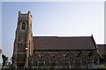
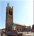
We're not in Kansas - Christ Church, Sparkbrook
One of several churches damaged in the tornado that hit Birmingham in July 2005, Christ Church, Sparkbrook, was already being considered for closure. Permission was given to demolish on health and safety grounds - but as the bulldozers moved in in June 2006, the church was spot-listed. It was demolished in 2007.
Image: © S Parish
Taken: 2 Jul 2006
0.20 miles