IMAGES TAKEN NEAR TO
Kyotts Lake Road, BIRMINGHAM, B11 1JT
Introduction
This page details the photographs taken nearby to Kyotts Lake Road, B11 1JT by members of the Geograph project.
The Geograph project started in 2005 with the aim of publishing, organising and preserving representative images for every square kilometre of Great Britain, Ireland and the Isle of Man.

There are currently over 7.5m images from over14,400 individuals and you can help contribute to the project by visiting https://www.geograph.org.uk
Image Map
Images are licensed for reuse under creativecommons.org/licenses/by-sa/2.0
Notes
- Clicking on the map will re-center to the selected point.
- The higher the marker number, the further away the image location is from the centre of the postcode.
Image Listing (47 Images Found)
Images are licensed for reuse under creativecommons.org/licenses/by-sa/2.0
Image
Details
Distance
1
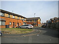
Cul de sac off Main Street, Sparkbrook
Apparently numbered as part of Main Street. On the right are the backs of shops fronting onto Stratford Road.
Image: © Richard Vince
Taken: 3 Sep 2022
0.14 miles
3
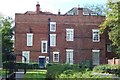
The Farm
Driving through on the main road, Sparkbrook looks like one of the grottiest places in Birmingham, but it's not such a bad place to live. There are lots of quiet streets, on one of which can be found one of the city's hidden gems: The Farm, the oddly named residence of the bank-founding Lloyd family. This is the rear view.
Image: © Adrian Bailey
Taken: 5 Oct 2004
0.14 miles
4
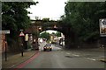
Kyrwicks Lane, railway bridge
Near intersection with Oughton Road, bridge "SKN/151, Kyrwicks Lane Between St Andrews Junction & Hazelwell" - bridge carrying freight line and diversionary route for intercity trains.
Behind camera is cul-de-sac section of road - no access to Highgate Middleway.
Image: © Michael Westley
Taken: 11 May 2011
0.15 miles
5
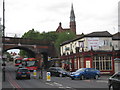
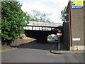
Shakespeare (pub and hotel)
On Stratford Road, Camp Hill, with railway bridge dominating the view north-west, and Bordesley Centre spire beyond
Image: © Michael Westley
Taken: 11 May 2011
0.15 miles
6
Main Street, Sparkbrook
Off Stratford Road, which is the actual main thoroughfare through Sparkbrook.
Image: © Richard Vince
Taken: 3 Sep 2022
0.15 miles
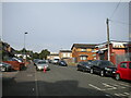
8
Housing off Main Street, Sparkbrook
In terraces at right angles to the road, with a token green space in front.
Image: © Richard Vince
Taken: 3 Sep 2022
0.16 miles
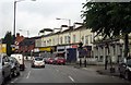
9
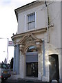
Midland Bank Sparkbrook. Sorting Code 40-11-30
I worked for Midland Bank HSBC for 32 years and spent all but the last two in Birmingham Branches. I am photographing all the branches, or what's left of them, as they were when I joined Midland Bank in 1963. The branches all start with the sorting code 40-11.
This was the 155, Stratford Road, Sparkbrook branch on the corner of Main Street. The sorting code was 40-11-30
Image: © Roy Hughes
Taken: 26 Dec 2008
0.16 miles
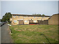
10
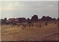
Camp Hill Goods station / yard (site)
Travelling on a train northward, having passed Balsall Heath and Highgate Road, the railway land once expanded greatly at the site of the old goods station / yard at Camp Hill. The same photo today would show the industrial estate that includes PC World at John Kempe Way.
Image: © Michael Westley
Taken: Unknown
0.17 miles