IMAGES TAKEN NEAR TO
Stratford Road, BIRMINGHAM, B11 1AN
Introduction
This page details the photographs taken nearby to Stratford Road, B11 1AN by members of the Geograph project.
The Geograph project started in 2005 with the aim of publishing, organising and preserving representative images for every square kilometre of Great Britain, Ireland and the Isle of Man.

There are currently over 7.5m images from over14,400 individuals and you can help contribute to the project by visiting https://www.geograph.org.uk
Image Map
Images are licensed for reuse under creativecommons.org/licenses/by-sa/2.0
Notes
- Clicking on the map will re-center to the selected point.
- The higher the marker number, the further away the image location is from the centre of the postcode.
Image Listing (78 Images Found)
Images are licensed for reuse under creativecommons.org/licenses/by-sa/2.0
Image
Details
Distance
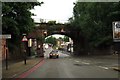
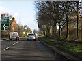
2
Shakespeare (pub and hotel)
On Stratford Road, Camp Hill, with railway bridge dominating the view north-west, and Bordesley Centre spire beyond
Image: © Michael Westley
Taken: 11 May 2011
0.08 miles
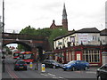
3
Camp Hill Goods station / yard (site)
Travelling on a train northward, having passed Balsall Heath and Highgate Road, the railway land once expanded greatly at the site of the old goods station / yard at Camp Hill. The same photo today would show the industrial estate that includes PC World at John Kempe Way.
Image: © Michael Westley
Taken: Unknown
0.11 miles
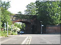
4
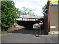
Kyrwicks Lane, railway bridge
Near intersection with Oughton Road, bridge "SKN/151, Kyrwicks Lane Between St Andrews Junction & Hazelwell" - bridge carrying freight line and diversionary route for intercity trains.
Behind camera is cul-de-sac section of road - no access to Highgate Middleway.
Image: © Michael Westley
Taken: 11 May 2011
0.11 miles
5
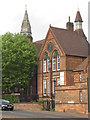
Bordesley Centre, Stratford Road
On approach to Camp Hill, an array of activities take place at the Bordesley Centre for Further & Higher Education. Image
http://www.muathtrust.org
Image: © Michael Westley
Taken: 11 May 2011
0.11 miles
6

Kyrwicks Lane railway bridge
One-way section of road, crosses under the freight railway line, at the point where once, the Camp Hill sidings began (hence why the bridge/tunnel is wider on the right-hand side than the left).
Beyond the bridge, Kyricks Lane is closed at junction with Oughton Road
Image]
Image: © Michael Westley
Taken: 11 May 2011
0.13 miles
7
Stratford Street North railway bridge
Freight line and railway bridge between St Andrews junction and Moseley. On left, just off photo, is a disused public car park
Image: © Michael Westley
Taken: 2 Jun 2011
0.14 miles
8
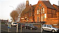
Bordesley Centre, Stratford Road
Sunsets on former education centre has had a varied 'career' - and is now a school again.
http://www.muathtrust.org/index.php?option=com_content&view=article&id=79:the-bordesley-centre-your-local-educational-centre-your-first-step-to-educational-success&catid=1:latest-news&Itemid=85
Image: © Michael Westley
Taken: 4 Mar 2011
0.15 miles
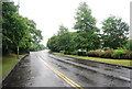
10
Highgate Middleway approaching Camp Hill Circus
Image: © Peter Whatley
Taken: 7 Dec 2011
0.17 miles