IMAGES TAKEN NEAR TO
Ardens Marsh, Sandpit Lane, ST. ALBANS, AL4 0JE
Introduction
This page details the photographs taken nearby to Ardens Marsh, Sandpit Lane, AL4 0JE by members of the Geograph project.
The Geograph project started in 2005 with the aim of publishing, organising and preserving representative images for every square kilometre of Great Britain, Ireland and the Isle of Man.

There are currently over 7.5m images from over14,400 individuals and you can help contribute to the project by visiting https://www.geograph.org.uk
Image Map (Loading...)


Getting Data...Please wait
Leaflet Map data © OpenStreetMap
Images are licensed for reuse under creativecommons.org/licenses/by-sa/2.0
Notes
- Clicking on the map will re-center to the selected point.
- The higher the marker number, the further away the image location is from the centre of the postcode.
Image Listing (5 Images Found)
Images are licensed for reuse under creativecommons.org/licenses/by-sa/2.0
Image
Details
Distance
4
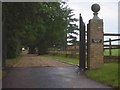
Entrance to house next to Oak Farm Coopers Green Lane
The appearance is one of opulence.
Image: © Jack Hill
Taken: 19 Aug 2005
0.20 miles
5
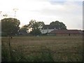
Oak Farm at Coopers Green Lane.
To far away from the road to get any idea of what
is happening.
Image: © Jack Hill
Taken: 19 Aug 2005
0.23 miles