IMAGES TAKEN NEAR TO
High Street, ST. ALBANS, AL3 8PQ
Introduction
This page details the photographs taken nearby to High Street, AL3 8PQ by members of the Geograph project.
The Geograph project started in 2005 with the aim of publishing, organising and preserving representative images for every square kilometre of Great Britain, Ireland and the Isle of Man.

There are currently over 7.5m images from over14,400 individuals and you can help contribute to the project by visiting https://www.geograph.org.uk
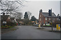
Image Map
Images are licensed for reuse under creativecommons.org/licenses/by-sa/2.0
Notes
- Clicking on the map will re-center to the selected point.
- The higher the marker number, the further away the image location is from the centre of the postcode.
Image Listing (74 Images Found)
Images are licensed for reuse under creativecommons.org/licenses/by-sa/2.0
Image
Details
Distance
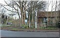
1
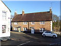
25/27 High Street, Markyate
18th century, grade II listed.
Image: © Robin Webster
Taken: 7 Jan 2018
0.02 miles
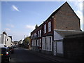
3
Junction of Cavendish Road and High Street, Markyate
Image: © Robin Webster
Taken: 7 Jan 2018
0.03 miles
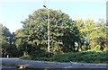
5
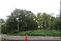
Woodland by London Road, Markyate
Back again, it's a useful route north. https://www.geograph.org.uk/photo/6614707
Image: © David Howard
Taken: 18 Oct 2020
0.03 miles
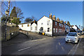
6
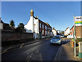
High Street, Markyate
Cavendish Road bus stop in the foreground.
Image: © Robin Webster
Taken: 7 Jan 2018
0.04 miles
8

The Old Malt House, Markyate
On High Street.
Image: © JThomas
Taken: 3 Aug 2019
0.04 miles
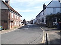
9
High Street Markyate
At the junction of Watling Street
Image: © David Howard
Taken: 9 Jan 2022
0.05 miles
10
Markyate : High Street
A road heading into Markyate off of the A5183.
Image: © Lewis Clarke
Taken: 24 Mar 2018
0.06 miles