IMAGES TAKEN NEAR TO
Wesley Road, ST. ALBANS, AL3 8PN
Introduction
This page details the photographs taken nearby to Wesley Road, AL3 8PN by members of the Geograph project.
The Geograph project started in 2005 with the aim of publishing, organising and preserving representative images for every square kilometre of Great Britain, Ireland and the Isle of Man.

There are currently over 7.5m images from over14,400 individuals and you can help contribute to the project by visiting https://www.geograph.org.uk
Image Map
Images are licensed for reuse under creativecommons.org/licenses/by-sa/2.0
Notes
- Clicking on the map will re-center to the selected point.
- The higher the marker number, the further away the image location is from the centre of the postcode.
Image Listing (73 Images Found)
Images are licensed for reuse under creativecommons.org/licenses/by-sa/2.0
Image
Details
Distance
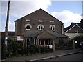
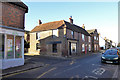
1
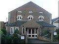
Former Methodist Church, Markyate
Situated in Wesley Road, this Church is one of several Methodist Churches in the recently established West Hertfordshire & Borders Circuit, having previously been in the Harpenden Circuit. Services are held here at 10.30am every Sunday with activities taking place during the week. The original entrance to this Church was in Albert Street, before this extension was built in Wesley Road. The notice outside this church says "MARKYATE METHODIST CHURCH. Please do not park here on Sundays between 9.30 - 12.30". The postcode of this Church is AL3 8PN. Update: the final service at this church took place at 3.00pm on Sunday 1st May 2022.
Image: © David Hillas
Taken: 13 Oct 2012
0.02 miles
2
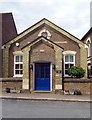
Wesleyan Sunday School (built 1880)
Converted into a private residence.
Image: © Jim Osley
Taken: 1 Aug 2014
0.03 miles
3
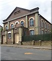
Wesleyan Chapel, Markyate
Built c.1859 - more details at this http://www.bedfordshire.gov.uk/CommunityAndLiving/ArchivesAndRecordOffice/CommunityArchives/Humbershoe/WesleyanMethodismInMarkyate.aspx.
Image: © Jim Osley
Taken: 1 Aug 2014
0.03 miles

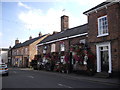
6
Markyate Pharmacy
A grade II listed building, 18th/19th centuries. The listing appears to include the attached housing behind, extending up Wesley Street.
Image: © Robin Webster
Taken: 7 Jan 2018
0.04 miles
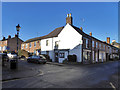
8
The Swan, Markyate
A grade II listed building, early 17th century or earlier, with an early 18th century brick front.
Image: © Robin Webster
Taken: 7 Jan 2018
0.04 miles
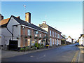
9
Houses on Markyate High Street
Grade II listed, 17th century or earlier with later brick fronts. The obviously reduced opening on the side facing Albert Street is very recent, formerly there was a shop window. Presumably this was done when the shop was converted to a house.
Image: © Robin Webster
Taken: 7 Jan 2018
0.05 miles
10
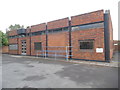
Markyate Telephone Exchange
Situated in Buckwood Road, this redbrick TE has the code SMMY and provides telephone and broadband services to 2,084 residential and 143 non-residential premises in Markyate plus Flamstead and Gaddesden Row nearby. A white BT warning notice can be seen on the front wall to the right of the building. This TE has the numbering range (01582) 84xxxx, the (01582) referring to the ten TEs in the Luton group, and its postcode is AL3 8JF.
Image: © David Hillas
Taken: 15 Sep 2018
0.05 miles