IMAGES TAKEN NEAR TO
George Street, ST. ALBANS, AL3 8NQ
Introduction
This page details the photographs taken nearby to George Street, AL3 8NQ by members of the Geograph project.
The Geograph project started in 2005 with the aim of publishing, organising and preserving representative images for every square kilometre of Great Britain, Ireland and the Isle of Man.

There are currently over 7.5m images from over14,400 individuals and you can help contribute to the project by visiting https://www.geograph.org.uk
Image Map (Loading...)


Getting Data...Please wait
Leaflet Map data © OpenStreetMap
Images are licensed for reuse under creativecommons.org/licenses/by-sa/2.0
Notes
- Clicking on the map will re-center to the selected point.
- The higher the marker number, the further away the image location is from the centre of the postcode.
Image Listing (34 Images Found)
Images are licensed for reuse under creativecommons.org/licenses/by-sa/2.0
Image
Details
Distance
1
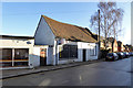
Premises to let, Markyate
Formerly a power tool shop.
Image: © Robin Webster
Taken: 7 Jan 2018
0.13 miles
4
Fusion Foods on London Road, Markyate
It was Massala Village but is still an Indian Restaurant, also called Markyate Grill.
Image: © David Howard
Taken: 9 Jan 2022
0.15 miles
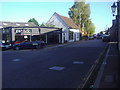
5
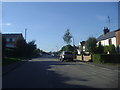
London Road, Markyate
The old A5 before it was bypassed.
Image: © David Howard
Taken: 27 Sep 2011
0.15 miles
7
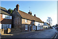
117/119/121, Markyate High Street
A grade II listed row, 17th century or earlier, with later alterations including a brick front. Remarkably there were two pubs here, the Old Red Lion up to 1914 for the middle house, and the Star and Garter up to 1970 for the near one.
Image: © Robin Webster
Taken: 7 Jan 2018
0.16 miles
8
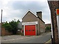
Fire Station at Markyate
Located in the heart of the village.
Image: © Jack Hill
Taken: 20 Aug 2005
0.16 miles
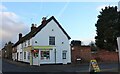
9
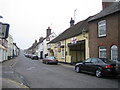
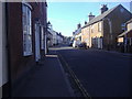
Markyate: The High Street
Once the Roman Road Watling Street, then the arterial A5 road, and then by-passed by the A5, this is now just the High Street in the centre of Markyate. The Sun Inn, which is the pale yellow building on the right side of the street, bears witness to its former use as a stagecoach inn. The 1884 Ordnance Survey map calls the town Markyatestreet.
Image: © Nigel Cox
Taken: 13 May 2006
0.16 miles
10
Sharose Court, Markyate
My guess is it's named after someone (or two people) with the names Sharon Rose.
Image: © David Howard
Taken: 20 Apr 2016
0.17 miles