IMAGES TAKEN NEAR TO
Old Watling Street, ST. ALBANS, AL3 8LT
Introduction
This page details the photographs taken nearby to Old Watling Street, AL3 8LT by members of the Geograph project.
The Geograph project started in 2005 with the aim of publishing, organising and preserving representative images for every square kilometre of Great Britain, Ireland and the Isle of Man.

There are currently over 7.5m images from over14,400 individuals and you can help contribute to the project by visiting https://www.geograph.org.uk
Image Map
Images are licensed for reuse under creativecommons.org/licenses/by-sa/2.0
Notes
- Clicking on the map will re-center to the selected point.
- The higher the marker number, the further away the image location is from the centre of the postcode.
Image Listing (9 Images Found)
Images are licensed for reuse under creativecommons.org/licenses/by-sa/2.0
Image
Details
Distance
1
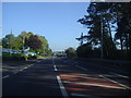
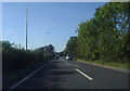
The A5 passing the Holiday Inn, Markyate
Image: © David Howard
Taken: 27 Sep 2011
0.09 miles
2

The Moat Hotel on Watling Street Nr Markyate
Obviously a good spot for a hotel.
Image: © Jack Hill
Taken: 20 Aug 2005
0.11 miles
3

Holiday Inn Luton - South M1, Jct.9
On London Road, Markyate.
Image: © JThomas
Taken: 3 Aug 2019
0.14 miles
4
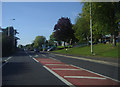
The A5 passing the Holiday Inn, Markyate
Image: © David Howard
Taken: 27 Sep 2011
0.17 miles
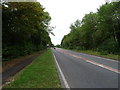
6
Borough of Dacorum : The A5183
Heading through the Borough of Dacorum on the A5183 between Flamstead and Markygate.
Image: © Lewis Clarke
Taken: 24 Mar 2018
0.20 miles
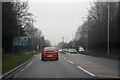
8
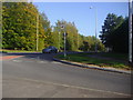
Junction of London Road and the A5, Markyate
London Road is the old A5, this short newer stretch is now the Markyate bypass.
Image: © David Howard
Taken: 27 Sep 2011
0.24 miles
9
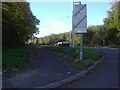
Junction of London Road and the A5, Markyate
Image: © David Howard
Taken: 27 Sep 2011
0.25 miles