IMAGES TAKEN NEAR TO
Windmill Road, ST. ALBANS, AL3 8LP
Introduction
This page details the photographs taken nearby to Windmill Road, AL3 8LP by members of the Geograph project.
The Geograph project started in 2005 with the aim of publishing, organising and preserving representative images for every square kilometre of Great Britain, Ireland and the Isle of Man.

There are currently over 7.5m images from over14,400 individuals and you can help contribute to the project by visiting https://www.geograph.org.uk
Image Map
Images are licensed for reuse under creativecommons.org/licenses/by-sa/2.0
Notes
- Clicking on the map will re-center to the selected point.
- The higher the marker number, the further away the image location is from the centre of the postcode.
Image Listing (4 Images Found)
Images are licensed for reuse under creativecommons.org/licenses/by-sa/2.0
Image
Details
Distance
1
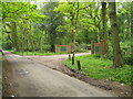
Markyate: Broomhills Shooting Ground
The entrance to the shooting ground on Windmill Road, the venue offers clay pigeon shooting, and cross bows and off-road driving amongst other activities, in the vicinity of Broomhill Leys Wood. Its website is here http://www.broomhills.co.uk/index.html
Image: © Nigel Cox
Taken: 13 May 2006
0.08 miles
2
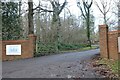
The entrance to Broomhills shooting ground, Markyate
Image: © David Howard
Taken: 9 Jan 2022
0.08 miles
4
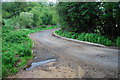
Dry Ford at Bonners Farm
This is the second of the two fords at Bonners.
Image: © John Walton
Taken: 12 May 2013
0.14 miles