IMAGES TAKEN NEAR TO
Buckwood Road, ST. ALBANS, AL3 8JF
Introduction
This page details the photographs taken nearby to Buckwood Road, AL3 8JF by members of the Geograph project.
The Geograph project started in 2005 with the aim of publishing, organising and preserving representative images for every square kilometre of Great Britain, Ireland and the Isle of Man.

There are currently over 7.5m images from over14,400 individuals and you can help contribute to the project by visiting https://www.geograph.org.uk
Image Map (Loading...)


Getting Data...Please wait
Leaflet Map data © OpenStreetMap
Images are licensed for reuse under creativecommons.org/licenses/by-sa/2.0
Notes
- Clicking on the map will re-center to the selected point.
- The higher the marker number, the further away the image location is from the centre of the postcode.
Image Listing (58 Images Found)
Images are licensed for reuse under creativecommons.org/licenses/by-sa/2.0
Image
Details
Distance
1
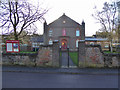
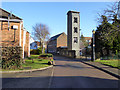
Markyate Baptist Church
On Buckwood Road.
Image: © Robin Webster
Taken: 7 Jan 2018
0.01 miles
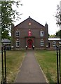
2
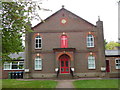
Markyate Baptist Church, Herts
Situated in Buckwood Road AL3 8JF, this church was erected in 1731, enlarged in 1832 and rebuilt in 1870. Services takes place here each Sunday at 10.30am, whilst activities are held during the week.
Image: © David Hillas
Taken: 9 May 2017
0.02 miles
4
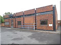
Markyate Telephone Exchange
Situated in Buckwood Road, this redbrick TE has the code SMMY and provides telephone and broadband services to 2,084 residential and 143 non-residential premises in Markyate plus Flamstead and Gaddesden Row nearby. A white BT warning notice can be seen on the front wall to the right of the building. This TE has the numbering range (01582) 84xxxx, the (01582) referring to the ten TEs in the Luton group, and its postcode is AL3 8JF.
Image: © David Hillas
Taken: 15 Sep 2018
0.04 miles
5
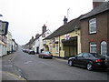
Markyate: The High Street
Once the Roman Road Watling Street, then the arterial A5 road, and then by-passed by the A5, this is now just the High Street in the centre of Markyate. The Sun Inn, which is the pale yellow building on the right side of the street, bears witness to its former use as a stagecoach inn. The 1884 Ordnance Survey map calls the town Markyatestreet.
Image: © Nigel Cox
Taken: 13 May 2006
0.05 miles
6
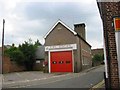
Fire Station at Markyate
Located in the heart of the village.
Image: © Jack Hill
Taken: 20 Aug 2005
0.05 miles
8
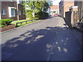
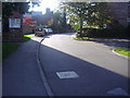
Park Field from Buckwood Road, Markyate
Image: © David Howard
Taken: 27 Sep 2011
0.06 miles
10
Tower, Markyate Fire Station
The rest of the station fronting the High Street looks rather older.
Image: © Robin Webster
Taken: 7 Jan 2018
0.07 miles