IMAGES TAKEN NEAR TO
Singlets Lane, ST. ALBANS, AL3 8EW
Introduction
This page details the photographs taken nearby to Singlets Lane, AL3 8EW by members of the Geograph project.
The Geograph project started in 2005 with the aim of publishing, organising and preserving representative images for every square kilometre of Great Britain, Ireland and the Isle of Man.

There are currently over 7.5m images from over14,400 individuals and you can help contribute to the project by visiting https://www.geograph.org.uk
Image Map (Loading...)


Getting Data...Please wait
Leaflet Map data © OpenStreetMap
Images are licensed for reuse under creativecommons.org/licenses/by-sa/2.0
Notes
- Clicking on the map will re-center to the selected point.
- The higher the marker number, the further away the image location is from the centre of the postcode.
Image Listing (5 Images Found)
Images are licensed for reuse under creativecommons.org/licenses/by-sa/2.0
Image
Details
Distance
1
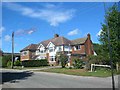
Houses in Singlets Lane Flamstead
Singlets seems a strange name for a road but I can think of more risque ones
Image: © Jack Hill
Taken: 28 Aug 2005
0.03 miles
2
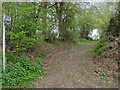
Chiltern Way
Chiltern Way heads off Delmerend Lane heading to the centre of Flamstead
Image: © Shaun Ferguson
Taken: 30 Apr 2010
0.11 miles
3
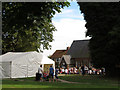
Flamstead Village Hall on Fete day
Picture taken from St Leonard's churchyard
Image: © Chris Reynolds
Taken: 8 Sep 2012
0.25 miles
4
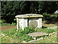
The Westcomb Altar Tomb, St Leonard's Churchyard, Flamstead
"In this vault are deposited the remains of William Westcomb of Cheverills Green who --- this Mortal life through the Mercy of God for a Blessed Eternity on the 26th day of September 1757 in the 70th year of his age. Also the Remains of Elizabeth his wife departed this life on the 13th July 1767"
Image: © Chris Reynolds
Taken: 8 Sep 2012
0.25 miles
5
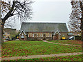
Village Hall, Flamstead
Viewed from the churchyard, this was once the village school.
Image: © Robin Webster
Taken: 16 Nov 2014
0.25 miles