IMAGES TAKEN NEAR TO
White Hill, ST. ALBANS, AL3 8DN
Introduction
This page details the photographs taken nearby to White Hill, AL3 8DN by members of the Geograph project.
The Geograph project started in 2005 with the aim of publishing, organising and preserving representative images for every square kilometre of Great Britain, Ireland and the Isle of Man.

There are currently over 7.5m images from over14,400 individuals and you can help contribute to the project by visiting https://www.geograph.org.uk
Image Map (Loading...)


Getting Data...Please wait
Leaflet Map data © OpenStreetMap
Images are licensed for reuse under creativecommons.org/licenses/by-sa/2.0
Notes
- Clicking on the map will re-center to the selected point.
- The higher the marker number, the further away the image location is from the centre of the postcode.
Image Listing (18 Images Found)
Images are licensed for reuse under creativecommons.org/licenses/by-sa/2.0
Image
Details
Distance
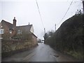
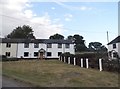
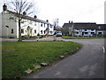
3
Trowley Bottom: Trowley Hill Road
The cottages on the north side of Trowley Hill Road viewed looking eastwards up the hill.
Image: © Nigel Cox
Taken: 25 Mar 2006
0.05 miles
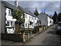
5
Cottages in Trowley Bottom
Compare and contrast http://www.geograph.org.uk/photo/5280862 (actually one concentrates on the ones on the right, this on the left but they do overlap).
Image: © David Howard
Taken: 13 Jul 2017
0.09 miles
6
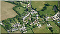
Trowley Bottom from the air
On the outskirts of Flamstead.
Image: © Thomas Nugent
Taken: 17 Jul 2024
0.09 miles
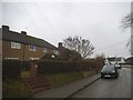
8
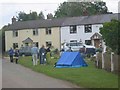
Trowley Bottom houses and sculpture project
The village was alive with people inspecting the exhibits based on sayings or happenings.
Image: © Jack Hill
Taken: 20 Aug 2005
0.11 miles
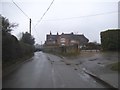
9
Trowley Bottom
Viewed looking eastwards towards Trowley Bottom Farm.
Image: © Nigel Cox
Taken: 25 Mar 2006
0.11 miles
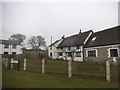
10
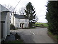
Trowley Bottom: Rose and Crown Free House
Viewed looking southwards from Trowley Hill Road.
Image: © Nigel Cox
Taken: 25 Mar 2006
0.12 miles