IMAGES TAKEN NEAR TO
Markyate, ST. ALBANS, AL3 8AU
Introduction
This page details the photographs taken nearby to AL3 8AU by members of the Geograph project.
The Geograph project started in 2005 with the aim of publishing, organising and preserving representative images for every square kilometre of Great Britain, Ireland and the Isle of Man.

There are currently over 7.5m images from over14,400 individuals and you can help contribute to the project by visiting https://www.geograph.org.uk
Image Map
Images are licensed for reuse under creativecommons.org/licenses/by-sa/2.0
Notes
- Clicking on the map will re-center to the selected point.
- The higher the marker number, the further away the image location is from the centre of the postcode.
Image Listing (4 Images Found)
Images are licensed for reuse under creativecommons.org/licenses/by-sa/2.0
Image
Details
Distance
1
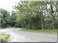
Unnamed road near Jockey End
Beechwood Park School grounds are on the right
Image: © David Howard
Taken: 13 Jul 2017
0.18 miles
2
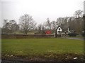
Lodge House at Gates to Beechwood Park School
The approach road is almost 3/4 kilometre long.
Image: © Jack Hill
Taken: 20 Aug 2005
0.20 miles