IMAGES TAKEN NEAR TO
Friendless Lane, ST. ALBANS, AL3 8AF
Introduction
This page details the photographs taken nearby to Friendless Lane, AL3 8AF by members of the Geograph project.
The Geograph project started in 2005 with the aim of publishing, organising and preserving representative images for every square kilometre of Great Britain, Ireland and the Isle of Man.

There are currently over 7.5m images from over14,400 individuals and you can help contribute to the project by visiting https://www.geograph.org.uk
Image Map
Images are licensed for reuse under creativecommons.org/licenses/by-sa/2.0
Notes
- Clicking on the map will re-center to the selected point.
- The higher the marker number, the further away the image location is from the centre of the postcode.
Image Listing (8 Images Found)
Images are licensed for reuse under creativecommons.org/licenses/by-sa/2.0
Image
Details
Distance
1
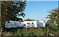
Motorhomes for hire at Cotton Spring Farm
These motor homes are often to be seen in the lanes near Flamstead making their way to M1.
Image: © Tom Presland
Taken: 12 Oct 2010
0.04 miles
2
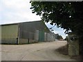
Cotton Spring Farm in Friendless Lane
The buildings tell of a successful enterprise
Image: © Jack Hill
Taken: 20 Aug 2005
0.07 miles
3
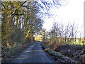
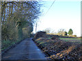
Friendless Lane
Friendless Wood is to the left.
Image: © Robin Webster
Taken: 7 Jan 2018
0.14 miles
4
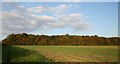
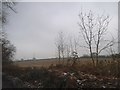
Friendless Wood
Seen from a Permissive Footpath provided by the landowner, but not shown on the OS map. The unusual name of the wood is not shown on the OS map either.
Image: © Tom Presland
Taken: 12 Oct 2010
0.17 miles
5
Friendless Lane
Cotton Spring is to the left.
Image: © Robin Webster
Taken: 7 Jan 2018
0.18 miles
7
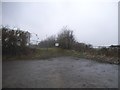
Field entrance on Friendless Lane, Markyate
Image: © David Howard
Taken: 11 Feb 2017
0.21 miles
8
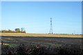
Pylon in field
North of Friendless Lane.
Image: © Robin Webster
Taken: 7 Jan 2018
0.22 miles