IMAGES TAKEN NEAR TO
Flint Way, ST. ALBANS, AL3 6DU
Introduction
This page details the photographs taken nearby to Flint Way, AL3 6DU by members of the Geograph project.
The Geograph project started in 2005 with the aim of publishing, organising and preserving representative images for every square kilometre of Great Britain, Ireland and the Isle of Man.

There are currently over 7.5m images from over14,400 individuals and you can help contribute to the project by visiting https://www.geograph.org.uk
Image Map (Loading...)


Getting Data...Please wait
Leaflet Map data © OpenStreetMap
Images are licensed for reuse under creativecommons.org/licenses/by-sa/2.0
Notes
- Clicking on the map will re-center to the selected point.
- The higher the marker number, the further away the image location is from the centre of the postcode.
Image Listing (7 Images Found)
Images are licensed for reuse under creativecommons.org/licenses/by-sa/2.0
Image
Details
Distance
1
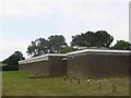
Changing rooms for football and tennis New Greens
The appearance is rather grim but the buildings suffer rough treatment
Image: © Jack Hill
Taken: 12 Aug 2005
0.13 miles
2
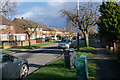
Woollam Crescent
A street in the outlying residential area of New Greens.
Image: © Bill Boaden
Taken: 29 Feb 2020
0.15 miles
3
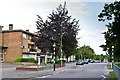
Shopping parade, High Oaks
Shopping parade on High Oaks, part of the 1940s/50s New Greens Estate.
Image: © Ian Capper
Taken: 26 Jun 2013
0.19 miles
4
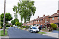
Carnegie Road
Part of the 1940s/50s New Greens Estate.
Image: © Ian Capper
Taken: 26 Jun 2013
0.20 miles
5

Parade of shops on High Oaks in New Greens
The group of shops includes the Co-op mini market and a post office.
Image: © Jack Hill
Taken: 12 Aug 2005
0.21 miles
6
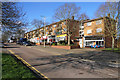
Row of shops in New Greens
The shops provide a focus in the centre of this outlying residential estate.
Image: © Bill Boaden
Taken: 29 Feb 2020
0.23 miles
7
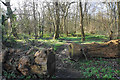
Batch Wood
Woodland on the edge of the New Greens estate which I presume is owned by the council. The path is an informal one.
Image: © Bill Boaden
Taken: 29 Feb 2020
0.23 miles