IMAGES TAKEN NEAR TO
Tanners Close, ST. ALBANS, AL3 5UN
Introduction
This page details the photographs taken nearby to Tanners Close, AL3 5UN by members of the Geograph project.
The Geograph project started in 2005 with the aim of publishing, organising and preserving representative images for every square kilometre of Great Britain, Ireland and the Isle of Man.

There are currently over 7.5m images from over14,400 individuals and you can help contribute to the project by visiting https://www.geograph.org.uk
Image Map (Loading...)


Getting Data...Please wait
Leaflet Map data © OpenStreetMap
Images are licensed for reuse under creativecommons.org/licenses/by-sa/2.0
Notes
- Clicking on the map will re-center to the selected point.
- The higher the marker number, the further away the image location is from the centre of the postcode.
Image Listing (12 Images Found)
Images are licensed for reuse under creativecommons.org/licenses/by-sa/2.0
Image
Details
Distance
1
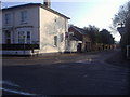
Junction of Branch Road and Verulam Road
Image: © David Howard
Taken: 4 Mar 2011
0.13 miles
2
Total garage on Verulam Road, St Albans
Image: © David Howard
Taken: 27 Sep 2011
0.13 miles

4

Romans Car Sales, 179 Verulam Road
Romans specialise in sports and prestige used cars. Ordnance Survey flush bracket number 1276 (a special type of bench mark) can just be seen halfway up the wall to the side of the vertical seam in the brickwork of the boundary wall.
Image: © Paul Collins
Taken: 27 Oct 2021
0.13 miles
5

Flush Bracket 1276, Verulam Road
A flush bracket is a special type of bench mark installed by the Ordnance Survey. This one, number 1276, was originally fixed into the wall of a building in about 1914 as part of a levelling line from Hemel Hempstead to Buntingford. At some stage, presumably during building alterations, it has been relocated into a new wall and hence probably slightly moved from its original position.
Image: © Paul Collins
Taken: 27 Oct 2021
0.14 miles
6
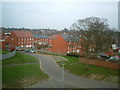
View from St Albans City Hospital
Taken from the Runcie Wing, named after the former Archbishop of Canterbury and Bishop of St Albans
Image: © Ray Stanton
Taken: 15 Apr 2006
0.14 miles
7
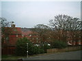
View from St Albans City Hospital
Another view from the same location. Abbey just visible through trees.
Image: © Ray Stanton
Taken: 15 Apr 2006
0.14 miles
8
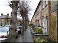
St Albans: Oster Street
In the St Albans Conservation Area, these neat Victorian terraced houses are in a cul-de-sac with pollarded trees.
Image: © Nigel Cox
Taken: 10 Jan 2008
0.22 miles
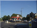
9
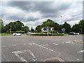
Batchwood Roundabout
Junction of the A4147 with the A5183, St Albans.
Image: © JThomas
Taken: 3 Aug 2019
0.22 miles
10
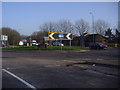
Roundabout at end of Redbourn Road A5183
Image: © David Howard
Taken: 4 Mar 2011
0.23 miles