
IMAGES TAKEN NEAR TO
Christopher Place, ST. ALBANS, AL3 5DQ
Introduction
This page details the photographs taken nearby to Christopher Place, AL3 5DQ by members of the Geograph project.
The Geograph project started in 2005 with the aim of publishing, organising and preserving representative images for every square kilometre of Great Britain, Ireland and the Isle of Man.

There are currently over 7.5m images from over14,400 individuals and you can help contribute to the project by visiting https://www.geograph.org.uk
Image Map
Images are licensed for reuse under creativecommons.org/licenses/by-sa/2.0
Notes
- Clicking on the map will re-center to the selected point.
- The higher the marker number, the further away the image location is from the centre of the postcode.
Image Listing (850 Images Found)
Images are licensed for reuse under creativecommons.org/licenses/by-sa/2.0
Image
Details
Distance
1
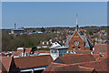
Christopher Place
The roof of Christopher Place, viewed from the Clock Tower. Beyond to the right of centre is Dagnall Street Baptist Church (see Image) and in the left background is the St Albans City Hospital.
Image: © Ian Capper
Taken: 20 Apr 2013
0.01 miles
2
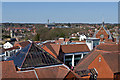
Christopher Place
The roof of Christopher Place, viewed from the Clock Tower. Beyond to the right of centre is Dagnall Street Baptist Church (see Image), in the background is the St Albans City Hospital and on the left is Christchurch.
Image: © Ian Capper
Taken: 20 Apr 2013
0.02 miles
3
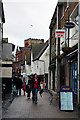
French Row
A combination of new and old buildings flank this narrow pedestrian thoroughfare. The tower of St. Albans Abbey can be seen above the roofs, whilst the sign of the Fleur-de-Lys public house at the other end of the street is visible above the pedestrians.
Image: © Martin Addison
Taken: 9 Dec 2007
0.02 miles


6

The White Swan
A locally listed pub in Upper Dagnall Street. After a brief period in 2010-11 calling itself Oscars, it has now reverted to its original name.
Image: © Ian Capper
Taken: 3 Dec 2011
0.03 miles
7

The White Swan
A locally listed pub in Upper Dagnall Street. After a brief period in 2010-11 calling itself Oscars, it has now reverted to its original name.
Image: © Ian Capper
Taken: 8 Jun 2019
0.03 miles
8
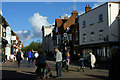
Echoes of the Ordinary
Seen in St.Albans, in Market Place, at the junction with French Row.
Image: © Peter Trimming
Taken: 5 Nov 2012
0.03 miles
9
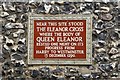
Eleanor Cross Plaque
Plaque on St.Albans clock tower http://www.geograph.org.uk/photo/567453
Following the death of Queen Eleanor in Harby, Notts on 28th November 1290, King Edward I erected an 'Eleanor Cross' at each of the places her funeral cortege stayed overnight on the way to Westminster.
St.Albans Abbey received the Queen’s body for the night of 13th December 1290 where the bier was placed before the high altar of the monastery “where it was during the whole night honoured with sacred offices performed with the utmost devotion”. The cross survived at least until 1640 and its base until 1702 though a year later the site had been cleared.
Image: © Richard Croft
Taken: 20 Sep 2007
0.03 miles
10

The Moot Hall
Originally thought to be the original Moot Hall, or Town Meeting Place, where the leaders of the Peasants' Revolt were tried in 1381. However recent research has shown that this building is later (late 16th century) and that the actual Moot Hall of the time was where the Town Hall now stands (see Image) - for a fuller account see http://www.stalbanshistory.org/page_id__226_path__0p2p145p147p.aspx.
Even if it has lost its place in national history, the building is still important, serving as St Albans' Town Hall for many years. It now houses the St Albans branch of W H Smith.
It is grade II listed - see www.historicengland.org.uk/listing/the-list/list-entry/1103069.
Image: © Ian Capper
Taken: 20 Apr 2013
0.03 miles