IMAGES TAKEN NEAR TO
Netherway, ST. ALBANS, AL3 4NE
Introduction
This page details the photographs taken nearby to Netherway, AL3 4NE by members of the Geograph project.
The Geograph project started in 2005 with the aim of publishing, organising and preserving representative images for every square kilometre of Great Britain, Ireland and the Isle of Man.

There are currently over 7.5m images from over14,400 individuals and you can help contribute to the project by visiting https://www.geograph.org.uk
Image Map
Images are licensed for reuse under creativecommons.org/licenses/by-sa/2.0
Notes
- Clicking on the map will re-center to the selected point.
- The higher the marker number, the further away the image location is from the centre of the postcode.
Image Listing (5 Images Found)
Images are licensed for reuse under creativecommons.org/licenses/by-sa/2.0
Image
Details
Distance
1
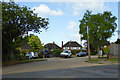
Westfields, St Stephens
A suburb of St Albans.
Image: © Robin Webster
Taken: 14 May 2017
0.07 miles
2
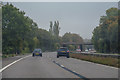
St Albans City and District : The A414
Heading along the A414 road.
Image: © Lewis Clarke
Taken: 4 Oct 2018
0.15 miles
3
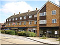
Abbey Avenue Shops
There used to be a newsagents, ironmongers, greengrocers, off license and butchers in this parade of shops. The newsagents now sells mainly groceries while the others have turned into a health clinic, beauty salon, hairdresser and optician. A nearby Waitrose could be the cause of the changes.
Image: © Ray Stanton
Taken: 30 Sep 2006
0.17 miles
4
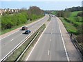
M10, from bridge.
Looking East from the bridge over the M10 at TL137055.
Image: © Rob Hinkley
Taken: 3 Apr 2005
0.20 miles
5
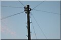
Traditional telegraph pole on St Stephens Avenue, St Albans
I don't know how they managed to do away with insulators but I still find the odd one which still has them.
Image: © David Howard
Taken: 13 Nov 2022
0.23 miles